Categories
Announcements Stations vivaNext.com Ways to win

Warden Station is now open!

Warden Station, your new rapid transit station, is Now Open!

The first built example of a rapid transit system is now open in York Region! We’re proud to announce that Viva vehicles began arriving at Warden Station in Markham on Sunday morning, and we were there Monday to celebrate with the morning commuters as the Viva Pink, Purple, and Green picked up and delivered customers at this new station through the morning rush hour.

Warden Station is at the intersection of Warden Avenue and Enterprise Boulevard, on the first rapidway segment in York Region. We’ll be building rapidways on Davis Drive in Newmarket, Yonge Street in Richmond Hill, and along Highway 7 from Vaughan to Markham, with a total of 71 vivastations similar to Warden Station located about one kilometre apart along each rapidway.

We’re really excited about opening Warden Station, and we want you to help us celebrate by entering our contest for your chance to win a 10-pack of 2-zone, adult Viva tickets!

Click here to enter the online contest.

Categories
General Uncategorized Urban Planning

A Transit-Oriented World

Transmetro Bus Rapid Transit system in Guatemala City, Guatemala

There are many cities where the fastest, most convenient way of getting around is by transit. Cities are planned and built over time, so no two cities are the same, and each one is planned based on identified needs or goals. A transit system built to meet an existing need may be effective in the short-term, but once a community is already built it can be complicated and costly to keep up with population growth by adding new transit infrastructure. To meet the long-term goal of an attractive destination to live, work, and play, transit systems need to be built beforehand to shape future development.

If they’re planned well, transit systems can be built with the ability to expand along with demand – for example from Bus Rapid Transit to Light Rail Transit. Building a transit system that will shape the community is the mindset, and the term we use for this is Transit-Oriented Development, or TOD.

TOD is a relatively new term but in one form or another, cities have been planned around transit for centuries. In historic Europe, roads, bridges and rail lines were built for wars, religious pilgrimages, and shipping goods, and where these roads met, communities grew. In Toronto, streetcar suburbs were created in the early 1900s as streetcar lines extended to new city limits with annexation to the north, west and east.

Currently, TOD is springing up all around the world on different landscapes and in different climates – Brisbane, Guatemala City, Hong Kong, and London to name a few. In North America, cities such as Vancouver, San Francisco and Arlington have a strong history of planning communities around transit, paving the way for similar developments in Edmonton, Calgary, Vancouver and Montreal. Closer to home, TOD is taking root in several communities such as Vaughan, Richmond Hill and Markham.

We’ve seen the sprawl that results when development happens without transit systems, and we can see worldwide examples of development springing up around transit routes and stations. Transit-Oriented Development is the urban planning of the future, but it’s strongly rooted in history – the traditional idea of a community with everything within walking distance or a short (fast!) ride away.

If you lived in a transit-oriented community, what amenities would you like to have nearby?

Categories
General Urban Planning

Locating utility lines – not always easy

Colour Code for Marking Underground Utility LinesHave you ever seen colourful markings along the side of the road, little coloured flags in a fun mix of colours stuck in the ground, or official-looking painted symbols on pavement, curbs and sidewalks and wondered what they mean?

It turns out that these markers aren’t just decorative – they mean something. In North America there is an established colour code for the markers, so that construction and utility workers everywhere will know where they should, and shouldn’t, dig.

Before the utility markers are put in place, we have to get “as-built drawings” from utility companies or from municipal records. As-built drawings are detailed treasure maps leading to utility lines, and although modern drawings are computer files, pre-1980s versions are hand-drawn. Some utility lines, such as water mains, can last up to 80 years. In most towns, each utility line was installed or replaced as needed over time, with separate record-keeping for each installation. This can make for a wide variety in age and design of drawings.

Once we have the as-built drawings, we mark the locations so that workers with utility location equipment will know where to dig – this is when the coloured flags and paint markings enter the picture. The markers are especially used where the utilities aren’t in a straight line, and may also point out other utility lines near the one we’re searching for.

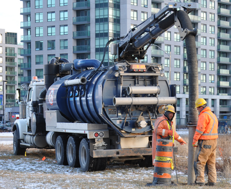
Now that we have a general idea of where a utility line is located, our workers bring out a hydrovac – a large, truck-mounted vacuum – to liquefy and vacuum bore a hole about a foot in diameter, downward into the soil. If we only want a small hole a few inches in diameter, test-pitting equipment is used instead. Both of these techniques are done carefully, and as we near the utility we dig cautiously by hand.

Relocating utility lines involves investigating a proposed location with digging equipment, and following local government utility planning guidelines. Utility lines are upgraded before being moved to their new location, and new as-built drawings showing the location, depth and width of each utility are created for future reference.

People locate utility lines before they start all kinds of projects – everything from digging a hole for a sprinkler system in your yard to excavating for a big project. Our rapidway projects include widening roads so they definitely classify as big projects, and all of them will include moving some utility lines farther back from the road.

We’re relocating utilities along Highway 7 in Markham right now. If you’re interested in seeing where our projects will be in your neighbourhood, check out our system map, or sign up for construction updates if you’re interested in knowing what’s happening every step of the way.

Categories
General Rapidways

A hum of activity

Photo of hydrovac preparing for utility relocation
Hydrovac crew bores a hole in the ground

There has been a hum of activity on Highway 7 lately. To be specific, the hum of a hydrovac – a large truck-mounted vacuum used to bore holes in the ground. We’re widening some of York Region’s roads to add dedicated rapidway lanes, but to do that we need to locate utility cables and pipes in the ground, and then use a variety of trucks and tools to move all of the utilities further back from the roads.

In terms of utilities, all roads are not the same. Which utilities are in place, where they are placed, and who is responsible for them varies for each section of each road. Electrical power lines and telecommunication wires are often located aboveground on poles, but sometimes they’re buried underground. Gas lines, and sewer and water main pipes are also underground, but not necessarily located together.

In many cases, the utilities need to be moved in a certain order to spots designated by York Region’s Transportation Services Department, Corridor Approvals and Records Branch with input from the construction company. This branch ensures utilities are installed in appropriate locations and keeps record of utility locations. Each organization moves their own utilities and, while doing so, uses the opportunity to check over the equipment or upgrade it.

Municipal government is usually responsible for sewer and water main pipes, but a team effort is important in cases where they cross municipal boundaries. For example, the intersection of Highway 7 and Yonge Street includes land within the Town of Markham, the Town of Richmond Hill, and the City of Vaughan. Gas, electricity and telecommunication companies also vary depending on the location. At vivaNext we work with all of these stakeholders to accommodate schedules and procedures, ensuring we reach our goal of relocating utilities in time for the next scheduled construction activity.

Categories
Community Events

And good will to all

Click here to see a video of vivaNext staff decorating gingerbread houses and delivering gifts to York Region's Children's Aid Society

Over the past few weeks, vivaNext staff has been adding to a box of gifts to donate to York Region’s Children’s Aid Society (CAS). Mostly gifts of toiletries and practical items for tweens and teens – things we sometimes take for granted but that can be luxuries to a youth on a tight budget. The CAS’ Holiday Heroes program welcomes all gifts, so staff also donated some items for kids of all ages. We then turned a staff meeting into a highly competitive gingerbread-house decorating contest so that we could donate them as well to unsuspecting families.

When we dropped off the donation to CAS last week, we had an opportunity to tour the warehouse where the gifts are sorted for distribution. We spoke to Dennis, who has a full-time job but volunteers his free time at the warehouse to ensure the gifts are ready to be delivered to children and families. We said hello to another Family Services Worker as she was picking up a carload of gifts Dennis had set aside for her to deliver to children and families she works with. The gifts in the warehouse are organized on tables by age group mostly, but there are some extra tables with gifts like our gingerbread houses that aren’t easily categorized.

At first glance it seemed like there were a lot of gifts, but the warehouse was far from full. As we left the warehouse, we were thinking how much our donation was needed and how relatively easy it was for our group to organize a contribution. Sometimes the good will of the holiday season brings about great things. So while this experience is still fresh in our thoughts, we’re thinking of other ways we at vivaNext can help people in our communities.

Click here to see a video of vivaNext decorating gingerbread houses and delivering donated gifts to the York Region Children’s Aid Society.

Categories
Live-work-play Urban Planning

Building a bridge between the past and future

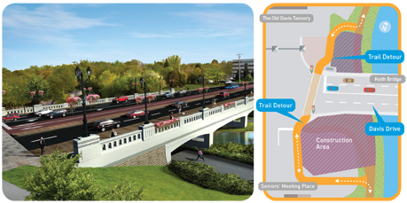
The future Keith Bridge on Davis Drive in Newmarket, and diagram of the Tom Taylor Trail detour

A sense of history and attractive landmarks can give us a feeling of stability and pride in where we live; making us even happier with the town and neighbourhood we live in. Voted one of the best places to live in Canada by MoneySense Magazine, Newmarket ranks 15 out of 179 Canadian communities.

People who call Newmarket home have discovered the heritage and scenic areas in the centre of town. The East Holland River is the historic backbone of Newmarket, flowing alongside historic Main Street, under the Keith Bridge on Davis Drive and north to Lake Simcoe. In the 1800s, Newmarket residents used the river for industry and irrigation. Today it’s used for recreation, following along the Tom Taylor Trail. Recently those using the trail have seen some detour signs where it normally passes under the Keith Bridge. The detour directs people to cross at the traffic lights on Davis Drive, and pick up the trail again on the other side.

Over the next year, we will be widening the Keith Bridge to allow for rapidways to be constructed on Davis Drive from Yonge to the Southlake Regional Health Centre. As we widen the bridge we’ll also be enhancing it, adding architectural features such as stonework, railings and light fixtures that provide interest and reflect Newmarket’s heritage.

Completing the beautiful new Keith Bridge by the end of 2011 is a major part of the Davis Drive transformation that Newmarket residents will be watching with excitement over the next three years.

Categories
Community Events

The vivaNext Team welcomes the fall season!

Markham Fair

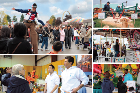
It’s that time of year again! The Markham Fair starts this Thursday and the vivaNext team will be there!

There has been a great deal of progress made on vivaNext projects since last year’s Fair – that’s why we encourage you to drop by our indoor booth for an update! We’re particularly excited about the progress of the Enterprise rapidway in Markham, which is due for completion by the end of this year. We’re also gearing up for more work on the Highway 7 rapidways. With plenty of information and great news to share, the vivaNext team is looking forward to answering your questions about rapid transit in Markham and York Region.

We hope that you enjoy the wide selection of food, live entertainment, activities and competitions the Markham Fair has to offer. This annual event is one of the oldest country fairs in Canada, and is a great way to spend time with family and friends, connect with the community, and welcome the fall season!

See you there!

For a coupon offering $2.00 off adult admission to the Markham Fair, please click here.

Markham Fair

When: September 29 – October 3, 2010
Thursday – Saturday: 9am – 10pm
Sunday: 9am – 6pm

Where: Markham Fairgrounds
10801 McCowan Road, Markham, ON

Categories
Going Green Rapidways

Protecting the environment

Protecting the Environment

If you’re a regular reader of this blog, you’ve probably explored the vivaNext website and will have seen the information section on environmental assessments. But what that section doesn’t really describe, is why we do environmental assessments in general, and how they are done. So here is my version of Everything You Always Wanted to Know About Environmental Assessments.

To begin with, the premise of an environmental assessment is based on a really important principle: projects that are being built in a community (whether large, like a new power plant, or relatively small like a new street) must address any potential negative effects on the natural, social or structural environment. Equally important, is the requirement that the community – including all members of the public – be given opportunities to understand the planned project, what impacts it is likely to have and how those will be addressed, and to provide comments before the project is approved.

Our provincial and federal environmental assessment processes are the safety net that ensure a project has been carefully analyzed, and negative effects on the community are minimized. These environmental assessment processes also look at how a proposed project fits into a community’s plans for its future, to ensure it will enhance rather than interfere with a community’s vision for itself. Whether a project needs to go through the provincial process, the federal process, or both, depends on the type of project, the project proponent or owner, and the effects it will have.

All municipal infrastructure projects in Ontario are subject to environmental assessment under the Ontario Environmental Assessment Act. Depending on the type, complexity and potential effects of a project, it may be subject to one of the provincial environmental assessment processes, such as the Individual Environmental Assessment, Municipal Class Environmental Assessment or the new Transit Project Assessment Process, which now governs and expedites the environmental assessment and approval for transit projects. Although the steps and timelines differ for each type of provincial environmental assessment, all allow similar opportunities for the community and public agencies to comment on a project.

Each environmental assessment process involves evaluating a project to determine what impacts it will have, and how those impacts will be addressed. Impacts range from how the project will affect the natural environment (plants, wildlife, air, water and geography), to social effects such as increased noise and vibration, traffic impacts, and access to properties and businesses. Throughout the process, the public is consulted at prescribed stages. For instance, as part of the Transit Project Assessment Process, once the assessment has been completed and documented, it is made public for 30 days, during which anyone can review it and provide comments. At the final stage of the Transit Project Assessment Process, the Minister of the Environment has 35 days to either approve the project or require further work to be done. The entire process must take no more than six months.

Federal environmental assessments are done when a project may have an impact on an area within federal jurisdiction. For vivaNext projects, those areas are mostly related to navigable waters and fish habitat in rivers and creeks that will be crossed by our rapid transit lines. In the case of navigable waters, the intent is to make sure that our project will not have a significant effect on the public’s existing ability to access or use a waterway. An officer from the Navigable Waters office reviews our plans then literally comes and looks at all the watercourses our transit lines will cross, even the smallest creeks and streams, to see if either the roadway or any planned bridges will affect these waterways.

In the case of fisheries, we work closely with the local conservation authorities to assess whether the project will potentially harm fish habitats. In either case, if there is a chance that our project will have an impact, then a federal environmental assessment is required. Data collected during the provincial environmental assessment is used in the federal environmental assessment as far as possible to avoid duplication and a coordinated process has been developed to further improve efficiency. So far, the North Yonge Street corridor is the only Viva project that required a federal environmental assessment, which was completed on August 19, 2010.

Once the environmental assessment approvals are completed, we work closely with provincial and federal agencies, monitoring our projects to ensure we’ve lived up to our promises.
So as you can see, the entire environmental assessment process is a thorough and comprehensive one, as well as being totally transparent, to ensure the public knows what’s happening. I’d encourage you to read up on our vivaNext environmental assessments, and to also check out these links for more background information on the federal process and the provincial process:

Categories
Live-work-play Rapidways Urban Planning

Why “TOD” is great news for all of us

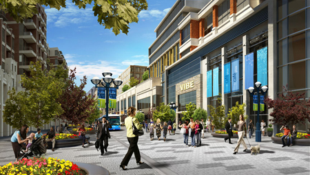
A rendering of transit-oriented development in Markham
A rendering of transit-oriented development at the future Markham Centre

Recently, I wrote about transit and the role it has in shaping communities, in particular, the development that tends to spring up along transit routes and around stations. This time, I want to talk more about what we mean by “transit-oriented-development” ( TOD for short), and why this kind of development will be good news for people in York Region—whether or not they are transit users themselves.

Most people get around York Region by car – possibly because they want to – but also because some people find it challenging to do all the things they need to do in a day by transit. That’s not surprising in a region like this one; in communities where development has been shaped by a long-standing car culture, destinations are more likely to be spread out, with greater distances between live-work-play destinations. Even the design of buildings may be shaped by car usage, with large parking lots separating buildings from roads.

The idea behind TOD is that people using transit are also likely to be pedestrians at some point during their journey – either at the beginning, or the end (or both). Studies have shown that people are willing to walk about 5 minutes to or from transit, which is somewhere between 400 and 600 metres. So TOD uses the approach of creating a complete community within walking distance of transit – including workplaces, homes, shopping, recreation and services. The thinking is that if new developments are designed to be conveniently compact and appealing to pedestrians, people are more likely to leave their car at home for at least one of their trips. Obviously, the good news is that more people taking transit means fewer cars on the road, less pollution, and less gridlock.

So York Region planners have linked the plans for the vivaNext rapidways to land use policies that will result in more TOD along Viva routes and near vivastations. These policies will likely mean that much of the new development built around vivastations will be compact and mixed-use, providing housing, employment, retail, dining, services and recreation, all within a walkable distance of transit. Developments will also include more welcoming public spaces, attractive landscaping, and other amenities so that people enjoy being out and about.

How will this affect you? In a pre-TOD scenario, a typical day could start with a drive to work, then a drive to a restaurant for dinner, ending with a drive to a movie or concert before driving back home. With more TOD, you would have the choice of taking transit to work, then walking around the corner from the office to dinner, then strolling across the street for a show before grabbing a coffee and getting home again by transit. Same day, two different ways of getting around.

The point is that transit and TOD don’t have to change the way people live in York Region, but it will give us all more choices – in what we do, where we do it, and how we get there. We think that’s good news for everyone.

Categories
Going Green Rapidways Urban Planning

Colouring Viva blue – and green

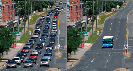
70-cars-before-and-after

The vivaNext rapidways being built across York Region are good news for the environment.  More people taking transit means less pollution. One Viva vehicle can replace up to 70 cars on the road – that represents a huge reduction in carbon emissions. With fewer cars on the road, gridlock, fuel use and air pollution caused by idling cars are all reduced.

There is also a direct connection between how our communities are developed, and the impact we have on our environment. Sprawling communities mean that people tend to travel farther between work, home and play. The more spread out a community is, the harder it is to provide efficient public transit. So, people become increasingly dependent on cars, and the developments that get built are more likely to be car-oriented. The more that happens, the less convenient it is for people to take transit. Eventually, entire communities become dependent on cars, and are less likely to use transit, cycle or walk to get around. More cars mean more gridlock, more pollution and more carbon emissions.

On the other hand, communities that are developed around great transit are more likely to include compact, pedestrian-friendly neighbourhoods.  Mixed-use developments and shorter distances between work-live-play destinations make it easier to get around and make transit a more appealing and convenient choice for a greater number of people.

The result: more people out and about, enjoying their energetic and dynamic local neighbourhood, and walking in the fresh air to ride in a comfortable, low-emission Viva vehicle.

And for people who continue to drive, their trips will be shorter due to the compact, mixed-use developments that have sprung up around transit – so once again, car usage will be reduced, resulting in less pollution and fuel consumption.

All of this is good news for the environment, for our health, and for our lifestyle.