Categories
Rapidways Uncategorized Urban Planning

A turn for the better: navigating the new traffic signals

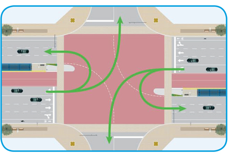
Intersection traffic patterns on Highway 7If you’re like me, traffic signals are one of those things that you automatically respond to without spending a lot of time thinking about them – if a light’s green it means you can go, and if it’s red you can’t. But when something is new, sometimes it helps to understand the reasons behind it. We’ve introduced new traffic signals on Highway 7 at the Leslie and West and East Beaver Creek intersections in December 2011, and want everyone to understand why they’re there and how they work.

As part of the vivaNext plan, rapidway lanes are being built in the middle of the road, making it much wider than it was in the past. The widening for this section of Highway 7 is now complete, so we’ve installed the new traffic signals at three of the intersections.

The new traffic signals include a protected left-turn arrow, which only allows left turns from Highway 7 when the left-turn arrow is green. During the left-turn arrow signal, there is no straight-through traffic in either direction and no pedestrian crossings allowed.

The reason for installing the protected left turn arrow is because of the increased width in the road. With the rapidway running down the middle of the intersection, the left turn lanes aren’t opposite each other.  The protected left-turn arrow allows left-turning traffic to turn without the hazard of oncoming traffic.

When the protected left-turn arrow is lit, drivers in the left-turn lane can also make a u-turn in the intersection. In sections of road with rapidway lanes in the centre, drivers will access addresses or streets on the opposite side of the road by making a u-turn at an intersection. Intersections with the new traffic signals have a special “U-Turn Permitted” sign under the “Left Turn Signal” sign.

During construction, video detectors will sense traffic in the dedicated left-turn lanes and extend the duration of the left-turn arrow. Once construction is complete, a magnetic sensor known as a “loop” will be installed in the pavement to detect traffic and extend the left-turn arrow duration.
At times, it might take a bit longer to drive through an intersection that has the protected left-turn arrow, but overall, our corridors are changing for the better. As our population grows, Highway 7 will become increasingly urbanized (see our blog about how Highway 7 is changing), and Yonge Street and Davis Drive will follow, each with their own local character. Instead of feeling like highways designed for cars, each street will feel like an urban area, with interesting destinations. The new traffic signals will be there to ensure drivers and pedestrians can navigate safely to their destination.

Diagrams of intersection traffic patterns:
Six-lane road, like Highway 7
Four-lane road, like Davis Drive

Diagrams of u-turn traffic patterns:
Six-lane road, like Highway 7
Four-lane road, like Davis Drive

Categories
Construction General

Davis Drive – noticeable change in 2011

Davis Drive in 2011

Davis Drive was a busy place in 2011, with lots of noticeable work done to prepare for rapidway construction. Rapidways will be built from Yonge Street to just past the hospital, and most of our work has been along this section.

Davis Drive will be widened starting in 2012, and we needed to do a few big things first: build retaining walls, widen the Keith Bridge, and relocate utilities.

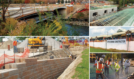
Widening Davis Drive will mean moving sidewalks and boulevards farther apart. In locations along the south side of Davis Drive where the ground slopes toward the road, retaining walls were needed so that we can move utilities. Five retaining walls are now built using stone blocks or textured concrete, with railings to be added to walls over two feet in height.

A new section of the Keith Bridge was built in 2011, including 106 tonnes of rebar steel reinforcements, and 110 truckloads of poured cement. Even though the final touches are still to come, the historical architectural features are noticeable in the new bridge construction. The Keith Bridge will be fenced this winter, and traffic will move to this bridge section at a later date.

Utilities, such as hydro, gas, sewage, and telecommunication lines, need to be moved to prepare for road widening, and in some cases they needed to be relocated as part of the Keith Bridge or retaining wall construction. Geotechnical testing – examining the condition and consistency of road and boulevard surfaces – has also been underway along Davis Drive so that our engineers know what to plan for when they widen the road.

This winter our contractors are working on 2012 construction schedules and continuing with utility relocation and geotechnical testing. When warmer weather arrives we’ll be ready to begin widening Davis Drive, and you’ll begin to see the overall transformation of Davis Drive into a welcoming urban place.

Happy Holidays everyone – we’ll see you in 2012!

Categories
Construction General

Highway 7 East: snapshot of 2011

2011 snapshot

If you’ve travelled along Highway 7 between Bayview and Warden during 2011, you’ll agree that construction has been underway for most of this year. The Highway 7 East rapidway project has firm timelines, and our contractors have been working hard to stay on schedule.

Earlier in the year, we removed the median from the centre of the road, installed a new watermain and started to relocate the utilities. Recently we’ve been installing landscape irrigation systems and continuing to relocate utilities. The construction between Bayview and Warden is part of a segment of rapidway that will connect to Warden Station, the first fully-built rapid transit vivastation, that opened for service in March, 2011.

We’re just finishing up widening Highway 7 on both sides between Bayview and Highway 404, and we have important changes to traffic patterns at intersections for both drivers and pedestrians. These changes are part of the next phase of construction, providing workers enough room to build the rapidway, and platforms and canopies of rapid transit stations.

Starting next week at the intersections of West Beaver Creek Road, Leslie Street, and East Beaver Creek Road, a dedicated left-turn signal is being added. This new signal will enable drivers to turn left and make U-turns only when no other traffic is moving. Left turns will no longer be permitted when oncoming traffic has the green light.

Wider roads mean wider intersections, so a two-stage pedestrian crossing will also be added. Pedestrians walking at a normal pace will cross to the centre island and wait for the next signal before reaching the other side. Once the rapidway is complete, this centre island is also where Viva passengers will be able to access a rapid transit station.

This has been an exciting beginning to an overall transformation of the corridor which will help shape our growing community for generations. We have many new goals to look forward to in 2012, and as we pass each milestone, the rapid transit network and welcoming streetscape will take shape.

Categories
Construction Going Green Urban Planning

New technology takes root: helping trees grow

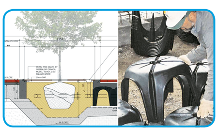
Diagram and photo of Cupolex

Among the beautiful benefits of the vivaNext project will be the improvements we’re going to make to the streetscape along York Region’s key corridors. A key part of those improvements will be carefully planned landscaping, including street trees planted at regular intervals for beauty and shade. Ensuring those trees survive in a tough urban environment is always a challenge, which is where science and technology come in.

Fortunately, our Landscape Architects are up to the challenge, and have tricks up their sleeves to keep our trees healthy and growing strong. To begin with, choosing the right tree is critical. Street trees, especially ones along roads carrying a lot of fast-moving traffic, need to be the kind that can stand up to salt spray and pollution from vehicles. Street trees also need to be relatively drought tolerant, and able to thrive without daily maintenance.

To meet these needs, our Arborist and Landscape Architects focused on a range of hardy trees, including different types of gingko, oak, maple, common hackberry, Kentucky coffee tree, ornamental pear and elm.

Once they’d solved the issue of which trees to plant, Landscape Architects turned to the other big problem facing urban plantings: large trees need a lot of soil around their roots. In a boulevard, there’s only so much room for soil, so trees generally don’t have the underground space they need to grow strong roots and take in nutrients. Our team is using an ingenious solution called “soil cell technology.” This refers to the cutting-edge approach of constructing a rigid form underground that can be filled with soil and then covered up by sidewalks or even roads.

Our soil cell technology is called Cupolex®, and was originally designed as a technique to provide a solid underground framework for ductwork and cables. At first glance it looks like a plastic patio table, with hollow legs at each corner. A series of these patio tables are installed underground, with their legs interlocking, forming a large honeycomb shape – a soil cell – surrounding where the tree will be planted. Then concrete is poured into the legs and over the top, creating a hard, self-supporting shell strong enough to support the weight of vehicles. The boulevard and sidewalks are constructed right over top, with openings left for planting trees. Special access hatches and irrigation pipes are installed for future tree maintenance, and then nutrient-rich soil is blown in, and trees are planted in the openings.

We’re not talking a regularly sized planter full of soil: each soil cell holds at least 16 cubic metres of soil. And each cubic metre is about the size of a stove, so imagine 16 stoves worth of soil for each tree! A typical dump truck holds 8-10 cubic metres, so each tree is going to get more than a dump truck of soil. That’s a lot of soil, and it’s really going to help our trees’ survivability.

Our vivaNext pledge is to do the best planning now, for a beautiful and functional rapid transit system and streetscape. Creating healthy, strong trees that can be enjoyed for generations is part of that, and it’s something we can all be proud of.

Categories
Construction Uncategorized

What’s in a schedule?

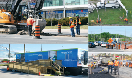
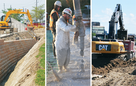
Construction crews work on vivanext projects, including building a retaining wall, pouring concrete for a bridge, and widening a road

For all of us working on the vivaNext rapidway projects, whether we work on communications or construction, some of the most frequently asked questions we hear are “how long is it going to take?” and “how soon will you be done working in my area?” We totally understand why this kind of information is important to everyone, and how upsetting it can be when work that has been scheduled, is rescheduled at the last minute.

Which brings me to this week’s topic – how do we come up with our construction schedules, and why do they occasionally need to be adjusted?

Developing and sticking to a construction schedule is something we take very, very seriously. We know how important it is to have an idea of when work will be underway nearby, and how long it will take. For us, having an accurate and realistic schedule is a critical part of project management.

Planning and following a construction schedule requires a combination of expertise and flexibility. Our construction partners have a huge amount of experience in building projects similar to the vivaNext project. Their scheduling teams understand construction techniques, they know how long each step in the process takes in average circumstances, and they know the best way to sequence the work.

Using that information, a highly detailed schedule is developed, showing when each major step of work will take place, broken down into blocks of roadway. One of our objectives is to complete work within a block as much as possible, to avoid having to come back to do more work in that location later.

Once the overall schedules are set and work begins out there in the real world, the need for flexibility kicks in. On a big design-build project like the vivaNext rapidways, schedulers work full-time to constantly evaluate the work underway, monitoring how long each task takes, and looking for ways to tweak the schedule for efficiency.

There are many reasons why a task may take longer than expected. Soil conditions may be different than expected, requiring a different construction technique or more investigations. Weather can cause all sorts of delays, and there may be delays with the delivery of materials.

It’s important to ensure work crews always have work to do. If one task is taking longer than expected, and another one is completed more quickly, crews will be redeployed to ensure their time is used effectively. Because there are so many tasks underway at a time on a huge project like ours, little adjustments are being made all the time.

On major corridors like Highway 7, Davis Drive and Yonge Street, one of the most complex issues is the need to relocate many utilities, such as gas lines, watermain systems, streetlights, telecommunications and hydro lines. Although we spend many months working closely with utility companies to plan for relocations in advance of construction, surprises can happen, where utilities are discovered that aren’t documented. So when that happens, our construction schedulers have the challenge of rearranging the entire schedule to allow for relocating the utility. (See our blog: Locating utility lines: not always easy)

Utility companies are responsible for actually doing the relocating, and they have crews working on projects all over the region, not just on our project. Sometimes, relocations – whether on our projects or somewhere else – take longer than originally anticipated. When that happens, delays cascade from one project to another, causing us to schedule other work to do while we wait for the utility relocation to take place.

And to make it all even more complicated, it’s not only our own work crews whose schedule we need to be aware of – there are other crews out working along Highway 7. Health and safety regulations require there to be separation in both time and distance between crews to ensure they all have enough space to work safely. So a change in the tasks being done by one crew may mean neighbouring crews may need to adjust.

All this adds up to a complex, multi-dimensional and constantly shifting challenge for schedulers. Their objectives are to maintain the overall schedule, while moving the project forward in the most efficient way possible. We know that from time to time, this causes the dates and times we originally provided to change to a later date. We recognize that (as much as possible) you want to know what construction to expect, and we’ll keep doing our best to keep you up to date – with e-updates, bulletins and other communications.

And we hope you’ll understand that when we do make a change, it’s because we’re doing our due diligence to finish the rapidway projects on schedule, so that everyone can benefit.

Categories
Urban Planning

Bus Rapid Transit: South America leads the way

Inside a BRT station in Curitiba – photo by www.ThomasLockeHobbs.com

The vivaNext rapidways project is one of a relatively small number of Bus Rapid Transit projects here in Canada, or for that matter in North America. There are BRT systems in Canada and the US, but the number of cities with BRT systems planned is relatively small, compared to the number of cities that would benefit from better transit.

What’s really interesting is how many cities around the world use BRT – cities with enormous populations and transit usage. Transit experts at EMBARQ (the Sustainable Transport wing of the World Resources Institute, an environmental think tank) estimate there are 120 cities around the world with BRT systems. And South America has taken to BRT enthusiastically, with BRT systems in 32 cities – more than a quarter of the total BRT systems around the globe.

One of the earliest BRT systems in the world was built in Curitiba, a large city in the south of Brazil with a population of just under 2 million within a larger metropolitan area. Other systems have been built all over South and Central America, including in all the major cities like Guatemala City, São Paolo, and Bogotá. There’s no doubt those systems are a spectacular success – transit ridership numbers in South American cities are huge. The Curitiba system carries a whopping 2.3 million riders per day, using 72 kilometres of median bus rapidway. Or how about São Paulo, with 104 kilometres of bus lanes, and a daily ridership of 5.7 million!

Besides a convenient way to get around, cities with bus rapid transit have been shown to have reduced commute times, lower tailpipe emissions and fewer traffic fatalities. And a key part of the success of these successful systems is that transit was built early on, and the surrounding land use was shaped by rapid transit. People became accustomed to taking transit, and transit-oriented development followed.

It’s exciting to think of the benefits vivaNext rapid transit projects will bring to our region. We know that there are differences in climate, landscape, and culture between South and Central American cities and York Region, but there are examples of BRT elsewhere in the world, and I’ll talk more about those next week.

Categories
Construction

Our pledge to you

Click here to see the Pledge campaign poster

You probably can guess that I’m very proud to be involved in our vivaNext rapidway construction project underway on Highway 7. I believe – as does everyone who works here – that this project is going to be great for York Region.

We thought people in York Region might find it interesting and reassuring to meet some of the professionals who are part of the vivaNext Highway 7 East rapidway project, and to hear what those individuals personally hope to achieve through their own work. This is the thinking behind our “Pledge” campaign, which you may have seen in posters or video.

The pledge campaign is our commitment to the community – that our design will reflect state-of-the-art technology and transit planning and that it will incorporate detailed urban design elements for beautiful and welcoming streetscapes.

Our construction project will be carefully planned and implemented to minimize disruption as much as possible, and to time the noise and delays for the least inconvenience for commuters, businesses and residents.

We are committed to being careful stewards of the natural environment while we work, to ensure we cause no harm to vegetation, fish or wildlife through the construction project.

And last but not least, we will be transparent and open in providing all the information people need while construction is underway. We will be available to anyone who has a question, comment or concern, through our Community Liaison, Nimisha Raja.

All of us working on vivaNext, whether we’re named in the campaign or not, are personally and professionally proud to be a part of building this state-of-the-art rapid transit system. And we want everyone in York Region to know you have our word on it.

Categories
Live-work-play

Summertime fun made easy on YRT\Viva

Summertime fun made easy on YRTViva

It’s already August, but the weatherman is saying that there’s still lots of summer to be enjoyed here in York Region. Happily, all across York Region there are lots of great ways to relax and cool down. Whether your idea of fun includes cooling off by a beach, watching the kids in a wave pool, or taking in a performance at a concert or outdoor theatre, we’ve got you covered.

And even better, you don’t have to get in a car to get there! YRT\Viva is a great way to get yourself to some summer enjoyment, whether you’re relaxing with friends, or taking the kids for an outing.

Want to have a picnic? Scare yourself on the biggest and fastest rollercoasters? Ride a bike on a forested trail? Or play a round of golf? Whatever your idea of fun looks like, the YRT\Viva Trip Planner makes it easy. You just put in the address you’re leaving from and where you want to go, and the trip planner works out the best route and gives you a schedule. It even has a built-in list of the major recreation destinations across York Region. Then grab your PRESTO card or bus fare and you’re on your way.

For some ideas, check out these links for recreation centres, pools, picnic parks and conservation areas, and then get out there and enjoy the second half of this amazing summer.

YRT\Viva Tripplanner: http://tripplanner.yrt.ca/hiwire

Lake Simcoe region Conservation Authority, conservation areas: http://www.lsrca.on.ca/conservation_areas

List of recreational activities available in Markham: http://www.guidingstar.ca/Recreational_Activities_in_Markham.htm

Website for your municipality – Markham, Newmarket, Vaughan, etc: http://www.york.ca/Municipal+Links/default.htm

Categories
Construction General

Working together to keep everyone safe

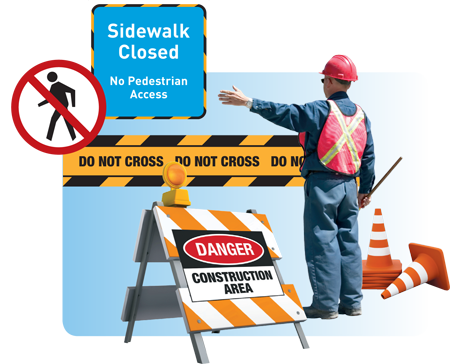
vivaNext construction signs

During the preliminary engineering phase of the vivaNext rapidway construction projects, as you might expect, our focus was on the design of our roadways, boulevards and stations. Now that we’re in active construction along Highway 7 and Davis Drive, one of our top priorities is safety – both for the public and for our workers. Our contractors have very detailed protocols for the steps they need to follow to keep their crews and members of the public safe, and ensuring safety is something we think everyone should take seriously.

The main challenge, as I previously mentioned in a blog about construction staging, is that our work has to happen on the edges and in the middle of some very busy roads. Closing all or part of Highway 7 isn’t an option, so our strategy there was to create as much separation as possible between active construction zones, and drivers and pedestrians. We created this separation by shifting the lanes away from the shoulders of the road, giving our workers more room to work, store materials and use heavy equipment.

To make sure everyone knows where the work zones are, we’ve posted signs and installed fences to clearly show that some areas are off-limits to pedestrians and drivers. We’ve put in place temporary sidewalks and temporary bus stops to ensure pedestrians have a clear path around work zones, and signs to make sure drivers can find temporary entrances to businesses and addresses. Every single crew member working for us is reminded and drilled regularly on what they need to be doing to stay safe, and keep you safe too.

Most drivers and pedestrians follow signs and stay away from construction areas, but sometimes pedestrians try to take shortcuts through work zones. It may seem like there’s little risk to doing this, but the reality is that work zones are filled with potential hazards for those who aren’t trained and wearing safety gear. Unexpectedly entering a construction site can put you and others at risk. Wires just below the surface, sharp objects, uneven ground and other hazards can lead to injuries. And the risk of walking near or around heavy equipment or vehicles, especially when they’re backing up, needs no explanation. Our crews know all the potential hazards, which is why they follow safety procedures and wear protective, highly-visible clothing, headgear and footwear at all times.

We hope every member of the public will respect this need for safety as well, and do the following:

>> Consider construction sites out of bounds, at all times – even when workers aren’t on site. Fences and no entry signs are there for a reason, even if you can’t see the reason.

>> Follow signs for temporary pathways or detours, even if the original route seems to still be available. We know your time is important and we wouldn’t create a detour if it wasn’t absolutely necessary.

As we go about our projects, we know that our construction disrupts the life of pedestrians, transit riders and drivers, and we do everything we can to do that as little as possible by keeping as many sidewalks, transit stops and traffic lanes open as we can, and minimizing detours and delays.

We hope that as you pass by our construction areas you’ll keep safety in mind too, and help us keep everyone safe.

Categories
General Rapidways Subways

York Region is ready to Presto

PRESTO card and fare machine

In London, it’s an Oyster. In Hong Kong, they call it an Octopus. Boston has its Charlie Card, and Atlanta loves its Breeze. And now York Region – along with other GTHA and Ottawa municipalities – is moving into the ranks of cities with smartcard technology for their transit system.

I’m talking of course about the launch of PRESTO this week in York Region on YRT\Viva services. PRESTO was developed through a partnership with the Province of Ontario, GO Transit and nine municipal transit partners in the Greater Toronto and Hamilton Area and in Ottawa, and will allow customers to ride on any participating transit system without pre-purchasing printed tickets or tokens.

Having access to PRESTO is great news for transit riders in York Region. Because PRESTO uses “stored-value” fare payments, customers can reload their card on the PRESTO website or at designated locations, and never have to worry about having a printed ticket or the right change. All you have to do is tap your card either on the PRESTO card reader at a vivastation before you board Viva, or on the on-board PRESTO machine on a YRT bus, and the system will automatically deduct the fare from your card’s balance (GO Transit riders also tap off at the end of their trip).

Smartcards are the way of the future for all great transit systems, and with good reason. These cards speed up the process of buying transit fares, they eliminate the paper waste associated with tickets, and they mean you’ll never need to rummage through your pockets for bus fare again.

One of the most important, long-term benefits is that, because smartcards often involve multiple transit services, they make it easier for passengers to travel across municipal boundaries. Instead of needing to purchase individual tickets for separate transit services, PRESTO is the only ticket riders will need to use on any participating system, including YRT\Viva, GO Transit (selected rail stations), Brampton Transit (ZÜM), Burlington Transit, Hamilton Street Railway, Mississauga Transit (MiWay), Oakville Transit, OC Transpo (Ottawa) and at select  TTC subway stations. And more stations and transit agencies are joining PRESTO throughout 2011 and 2012.

The PRESTO website and call centre (1-8-PRESTO-123) have all the information you’ll need to learn more about how PRESTO works in general, and where it can take you.

To introduce riders to PRESTO, YRT\Viva has representatives showing riders how to use PRESTO, helping them register online, and distributing up to 5,000 specially-priced cards. To get your new PRESTO card, check out the YRT\Viva website for distribution locations and hours.