Categories
Construction General Live-work-play Rapidways Stations Urban Planning

what’s a rapidway?

The word rapidway is new to most people, but pretty soon it’s going to be a very familiar concept for people in York Region.  We’ve had lots of interest from people wondering how exactly the rapidway on Highway 7 is going to work once it’s in service this year, and whether it will result in any changes for drivers, transit users and pedestrians.  So to get you started, here’s a primer on some rapidway basics.  Then for more detailed information, check out this blog over the upcoming days and weeks, for lots more information about what’s being built and how it’s going to benefit all of us.

  1. Who can actually drive in the rapidway?
  2. The rapidway will only be used by vivavehicles.  YRT buses will continue to run in mixed traffic as they do now, and will continue to use their existing curbside stops.  The exception is emergency vehicles; fire, ambulance, police, who may use the rapidways to help them through traffic.

    Under no circumstances will cars or other vehicles ever use the rapidway.  We’ll have signs at the beginning of the rapidway in each direction, making it very clear that non-viva vehicles must not enter.

  3. How will I know how to stay off the rapidway?
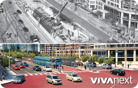
  4. We’ve made it easy to see where the rapidway begins, by paving the whole rapidway with distinctive bright red asphalt (see my blog in the next couple of weeks on red asphalt). It will be very obvious where the edges of the rapidway begin and end. To make it even more obvious, a rumble strip has been installed along the edges of the rapidway. Driving over the rumble strip will produce a loud noise if a driver begins to edge into the rapidway by mistake.

  5. How will I make a turn across the rapidway
  6. We’ve designed several features that will make it very clear where and when drivers can turn across the rapidway. (look for my blog in the next couple of weeks for more description of the new intersections and traffic signals). Left turns will only be allowed at intersections, which will have well-marked turning lines painted on them. The rapidways will have their own dedicated transit signals for viva drivers, which will be clearly marked and separate from the left turn signals for all other drivers. Lastly, there will be a protected left turn phase, meaning that drivers turning left (or making u-turns) will get a separate green arrow on its own phase, before through-traffic is allowed to move.

  7. How will pedestrians get to the vivastations?
  8. Every station is located adjacent to a signalized intersection, with a clearly marked crosswalk to make it easy to cross to the station in the median. Because Highway 7 with the rapidway lanes in the middle is now wider than it used to be, some pedestrians may want to cross the road in two stages, going to the median on the first stage, and then crossing to the other side on the second stage.

So that’s the most basic primer on how the rapidway will work, but I know people have many more questions. Over the next few weeks, I’m going to post an ongoing series of blogs on all the features of the new Highway 7 rapidway. But in the meantime, we want to know what you’d like more information on. Help us out by filling in your priority topics in this simple survey:

    [poll id=”43″]
Categories
Announcements Community Events General Rapidways Uncategorized

follow along this summer as we introduce you to some fun with the blue boots!

Anticipation is building as construction nears completion on the first section of the Highway 7 rapidway, as we get closer to seeing our designated bus lanes for viva fully operational this summer. You may have seen finishing touches applied to the canopies or even caught a glimpse of red asphalt being paved. It’s an exciting time for vivaNext and we want to share that excitement with you. With this in mind, we are pleased to introduce the Blue Boots – vivaNext’s mystery mascot if you will!

For the next six weeks, get onboard the fun bus and follow the Blue Boots Series, a six video summer project brought to you by our communications summer students. Every Wednesday, check our YouTube channel to discover where the boots are going, who they’ll meet and where they’re headed next! Each video will explore unique aspects of the vivaNext project that we hope will get you excited about riding viva.

So be ready to be moved with the Blue Boots today! Watch the first video by clicking this link.


Categories
General Live-work-play Rapidways Stations Urban Planning

bringing a long-term plan for the future to life, one step at a time

With crews working on the finishing touches on the western half of the Highway 7 rapidway, we’re getting closer to the day rapid transit finally becomes a reality for York Region.  As much as we’re looking forward to celebrating this milestone, it’s only one (very exciting) step in a long path that started years ago, and is going to take time to complete.

There’s a lot of media coverage these days on the general need for better transit all across the Greater Toronto and Hamilton Area (GTHA).  We’re proud that York Region has been actively working to bring rapid transit to our region.  In 2002 the Region produced the York Region Transportation Master Plan and the follow-up Rapid Transit Plan, committing the Region to a blueprint of multiple transportation initiatives to be built over the next 30 years.

With approval to the Rapid Transit Plan, we got to work quickly.  In 2005 the viva team – our formal name is York Region Rapid Transit Corporation – first launched “QuickStart”, the first phase of viva service.  Viva offered enhanced features that made transit more comfortable and convenient, and put the customer first in a way that was new for a transit service in the GTHA. With ridership levels that have increased steadily, viva changed the way people in York Region viewed transit.

But while our new viva service was a major success and an important first step in encouraging people to try transit, designing the vivaNext rapid transit system was our longer-term priority. Since 2005, Provincial government policy has required that Ontario municipalities plan for sustainable, more intensive land use, and rapid transit is a key component to achieve that goal.  Anticipating this, the 2002 Transportation Master Plan directed that future growth in York Region would be concentrated in new downtowns in Markham, Newmarket, Richmond Hill and Vaughan. By building more intensively in these areas, there would be less pressure for growth in existing neighbourhoods and a reduction in traffic congestion.

These urban centres would be connected by transportation “corridors”, making it easier for people to get around the region. The vivaNext rapidways will be built along the corridors, providing connections across York Region and into the rest of the GTHA.

Much of the new development built around vivastations will be compact and mixed-use, providing housing, employment, retail, dining, services and recreation, all within walking distance of transit. Developments will also include more welcoming public spaces, attractive landscaping, and other amenities that will contribute to the centres becoming more dynamic destinations.

Our plan is well and truly underway, and rapidways are being built on Highway 7 in both the east and west, as well as in Newmarket. The Toronto-York Spadina subway extension is under construction, and the design for rapidways on Yonge Street are being finalized.  Great new developments are popping up all over the new urban centres across the Region.

So when the first rapidway on Highway 7 starts service this year, we’re going to be celebrating the implementation of the first phase of our transportation and growth management blueprint.

We have many more phases to deliver, but with such a clear plan to follow, people in York Region can be assured it’s going to come true.  Check out our construction progress so far.


Categories
Construction General Rapidways Urban Planning

let’s talk construction

There’s an old joke that there are two seasons in Canada – winter and construction. Like the weather, road construction in York Region can’t be avoided; it must be endured.  But we all know that once the projects are done, we can enjoy our refreshed streets and the opening of the improved viva service in its own rapidway.

There’s no doubt that road construction would be completed a lot faster if we could just block off the necessary sections and do the full width and length all at once. Understanding people still need to get around; we do our best to work around traffic.  This means work progresses more slowly; in addition to needing Mother Nature on our side, we have to use smaller equipment and work in smaller sections. This may result in every stage taking longer. For example, paving requires only a few hours, but new pavement can’t be travelled on right away.  We schedule our paving work carefully to try to avoid paving during the most congested times of the day.

And sometimes you may wonder why we’ve returned to an area even though it seemed like we were finished. In fact, what you’re seeing is that we are coming back to complete work which has to be done in a certain order or in layers. Everything has a sequence and a process to finish the job.

To minimize overall duration and immediate impacts to motorists, residents and businesses, crews sometimes work 24/7 – weather permitting. This enables work to be completed in an area or on a piece of the construction that has a higher impact so that crews can then move on to the next section.

The good news to remember is once the final paving is finished, the biggest disruption of construction will soon be coming to an end. Once construction of the vivaNext rapidway project is complete in that area, we can all enjoy our new streets and boulevards and the anticipated opening of the new viva rapidway service.

We appreciate your patience throughout construction. We’ll make sure you know exactly where and when any lane closures are going to take place, to help you minimize any inconvenience. Look for our emails giving you the latest updates on where we’ll be working, and how long our work will take. Click here to sign up for construction notices, and to get the latest on the paving on Highway 7.

Sometimes, making it through traffic is only a matter of being prepared for the congestion.  Here are some wise words and a few recommended tips to help keep your cool and pass the time.  And as always, we thank you for your patience.


Categories
General Rapidways Stations Subways Uncategorized Urban Planning

Exploring Vaughan with vivaNext

With the early stages of rapid transit developments underway along Highway 7 West in Vaughan, now is the perfect time to reflect on everything this great city has to offer. Already an attractive destination for residents, businesses and visitors, Vaughan is a perfect location to integrate Bus Rapid Transit (BRT) rapidways and cultivate a thriving transit system.

Vaughan is comprised of six communities including Maple, Woodbridge, Kleinburg, Concord, Thornhill and Vaughan Metropolitan Centre [VMC]. With a growth rate of 80.2%, it was the fastest growing municipality in Canada from 1996-2006, and this diverse city shows no signs of slowing down.  The nation’s largest amusement park, Canada’s Wonderland, averages approximately 3.5 million visitors per season and the Kortright Centre for Conservation hosts around 135,000 visitors annually.

Vaughan is also home to many social, historical and cultural hotspots that maintain its reputation as a vibrant place to live, work, shop and eat. Residents and visitors can browse over 200 retail stores at Vaughan Mills, the 15th largest mall in Canada, or view an extensive collection of paintings by Tom Thomson, the Group of Seven and their contemporaries at the McMichael Canadian Art Collection in Kleinburg. Before hopping on a viva bus home, stop by Reptilia Zoo and visit “The King” – the largest venomous Cobra snake at any zoo in Canada, or tour the Thoreau MacDonald House – home of the Group of Seven painter J.E.H MacDonald from 1914 to 1974. Other various parks, theatres, recreation centres and educational institutions leave no shortage of things to do and explore.

The future rapidway vivastation at VMC will make travelling to and from your favourite places in Vaughan easier and more efficient. In the VMC, mixed-use transit-oriented development is proposed along a tree-lined main street, including businesses, residences, entertainment and cultural facilities, as well as pedestrian shopping areas. With connections to both the new TTC subway station and an inter-regional bus terminal, VMC will be one of the most ambitious development projects in the area’s history. It will be a convenient transportation hub unique to the city, and yet another main attraction that Vaughan can call its own.

Check out some more fast facts about Vaughan below:

  • Non-official languages include:
    Italian – 15.2% | Russian – 6.7% | Spanish – 2.7% | Tagalog (Filipino) – 1.9% | Punjabi – 1.8%
  • Twin city: Lanciano, Italy (2002)
  • Folklore associates the name “Maple” with the numerous Maple trees once found along Keele St.
  • The name “Woodbridge” derived from a wooden bridge that crossed the Humber River as an entry point into the town
  • A direct German translation of “Kleinburg” is small town

Follow the progress of the Highway 7 West rapidway in Vaughan by signing up for construction updates.

Think you know Vaughan? Test your knowledge with our interactive quiz! Play now.

Categories
Construction General Rapidways Uncategorized Urban Planning

Your Community Liaisons

You might recognize Nimisha Raja, Carrie Slattery or Michelle Dudzik, our community liaisons from Markham, Newmarket and Vaughan/Richmond Hill respectively, from our website or the construction bulletins you’ve signed up for or you may have met them at a vivaNext event.

But, we also have a new face joining forces with our three existing liaisons –  Tamas Hertel, the Community Liaison Specialist on Yonge Street in Richmond Hill and Newmarket. Over the past four months he has been quite busy.  Tamas has been making contact with businesses and residents along Yonge Street as preparation for future rapidway construction.

They are all readily available to answer any questions or assist you with everything related to the vivaNext project. You name it, whether you’re a property owner, business operator, tenant, special interest group, or any other interested stakeholder in York Region along the viva rapidway corridors, they are happy to hear from you.

All four of our Community Liaisons spend a lot of time out in the community, making presentations and answering questions about construction schedules and the projects in general. And with project information centres open in both Newmarket and Vaughan, you have more opportunity to stop by and meet your Liaison – check for the hours here.

We hope that our website, Facebook page, or construction bulletins continue to help you find answers to your questions. But if you would rather speak to someone, or you’re wondering about your specific property, Nimisha, Michelle, Carrie or Tamas are available and happy to talk to you.

Markham:
Nimisha Raja
Community Liaison Specialist
Telephone: 905-886-6767 Ext. 1023
1-877-464-9675
Cell phone: 416-712-8938
Email: nimisha.raja@york.ca

Newmarket:
Michelle Dudzik
Community Liaison Specialist
Telephone: 905-886-6767 Ext. 1096
1-877-464-9675
Cell phone: 905-716-7663
Email: michelle.dudzik@york.ca

Vaughan:
Carrie Slattery
Tel: 905.886.6767 Ext. 1129
1-877-464-9675
Cell: 289.716.0091
Email: carrie.slattery@york.ca

Yonge Street, Richmond Hill and Newmarket:
Tamas Hertel
Tel: 905.886.6767 Ext. 71357
1-877-464-9675
Cell: 905.505.1430
Email: tamas.hertel@york.ca

Categories
General Rapidways Stations Uncategorized Urban Planning vivaNext.com

Glossary of construction terms

Construction can be chaotic for the layperson with its oddly shaped machines digging, drilling and moving around dirt, concrete and other large items. It can be hard to understand what they’re doing exactly, but things can get even more confusing when construction terminology gets thrown around. To help anyone who might be interested we’ve compiled a list of our most often used terms, just for the fun of it –

Abutment A structure located at the ends of a bridge, where the bridge slab adjoins the approaching roadway.
   
Archaeological Testing/Assessment The examination of limited areas for the purposes of identifying historical artifacts. We do this work to meet the requirements of the 2007 North Yonge Street Corridor Public Transit Improvements Environmental Assessment, which identifies areas of potential archaeological interest along the Yonge Street corridor, so that we can ensure any important historical artifacts are identified before the roadway is widened for the rapidway.
   
Backfill Material used to replace, or the act of replacing material, removed during construction. Also, may denote material placed, or the act of placing material, adjacent to structures.
   
Bore Holes Drilling into the ground to bring up samples of earth for testing.
   
Boulevard A strip of grass between a sidewalk and a road, located above a curb.
   
Bridge Pier A supporting structure at the junction of connecting spans of a bridge.
   
Caissons A cylindrical concrete foundation that penetrates through soil to rest upon an underlying stratum of rock. Or the structural support for a type of foundation wall.
   
Canopy A curved glass and steel structure over a vivastation platform that shelters passengers.
   
Cast-in-Place A construction of forms filled with concrete at the final location.
   
Catch Basin A receptacle for catching water runoff from a designated area; usually a shallow concrete box with a grating and a discharge pipe leading to a plumbing or stormwater system.
   
Cofferdam A watertight steel enclosure from which water is pumped to expose the bottom of a body of water and permit foundation construction.
   
Corridor Area where vivaNext has construction underway – e.g. Highway 7 East, Highway 7 West, Davis Drive or Yonge Street.
   
Culvert A drain pipe or small bridge for drainage under a road or structure.
   
Cut and Cover A method of tunnel construction that involves digging a trench, building a tunnel, and then covering it with fill.
   
Daylighting The process of exposing buried utility lines to daylight.
   
Directional Drilling Drilling sideways under structures, roadways, streams, etc. to place pipes, utility lines without excavation and generally limited to less than 30cm in diameter.
   
Duct bank Groups of conduits designed to protect and consolidate cabling to and from buildings. Data and electrical cables are laid out within PVC conduits and bundled together; these groupings of conduit are protected by concrete and metal casings. Duct banks are often buried, allowing contractors to consolidate the wiring for a building into centralized underground paths.
   
Easement An interest in land owned by another that entitles its holder to a specific limited use.
   
Environmental Impact The effects a project will have upon the environment, especially the human environment.
   
Environmental Testing Is used to verify if a piece of equipment can withstand the rigors of harsh environments.
   
Excavator Generally tracked vehicle with rotating body and front mounted digging arm.
   
Geotechnical Testing The process of boring, sampling, and testing the soil at various depths to enable the geotechnical engineer to discover and analyze characteristics of the soil.
   
Guy Wires A wire used to secure a tall exterior mast, antenna, or other structure in place.
   
Hoarding A temporary wooden fence around a building or structure under construction or repair.
   
Hydrovac A large truck-mounted vacuum used to bore holes to locate underground utility cables and pipes.
   
Locates Markings that locate underground infrastructure, identified as follows:

  • Red – Electric power lines, cables and conduit systems and lighting cables
  • Yellow – Gas, oil, steam, petroleum, gaseous or dangerous materials
  • Orange – Communications, cable television, alarm or signal lines, cables or conduit systems
  • Blue – Water, irrigation and slurry lines
  • Green – Sewer and drain lines
  • White – Route of proposed subsurface line or location of proposed excavation
  • Purple – Reclaimed water
  • Pink (fluorescent) – Temporary construction project site survey markings and survey monuments.


Man Hole A hole through which a person may go to gain access to an underground or enclosed structure.
   
Precast (PC) Piles A reinforced concrete pile which is moulded in circular, square, rectangular or octagonal form.
   
Pile Driver A noisy machine that repeatedly drops a heavy weight on top of a post-like foundation until it reaches solid soil, rock or cannot be pushed down any farther.
   
Potholing A small, steep-sided hole usually with underground drainage.
   
Rapidway Dedicated lanes for viva rapid transit down the centre of the road [except on Enterprise Drive, where the lanes are beside the road].
   
Re-bar Ribbed steel bars of various sizes used to give concrete strength in tension.
   
Sheet Piling Planking or sheeting made of concrete, timber, or steel that is driven in, interlocked or tongue and grooved together to provide a tight wall to resist the lateral pressure of water, adjacent earth or other materials.
   
Storm Sewer A sewer used for conveying groundwater, rainwater, surface water, or similar non-polluting wastes.
   
Test Pitting An excavation made to examine an existing foundation, or to determine whether an area is suitable for building construction; includes the taking of soil samples and the determining of the depth of groundwater.
   
Transformer A device that changes, or transforms, alternating current from one voltage to another.
   
Vaughan Metropolitan Centre (VMC) Area around Highway 7 West in the City of Vaughan designated as a new development area.
   
Vivastation A bus rapid transit station on a vivaNext rapidway. Includes a platform in each direction, like a train station.
   
Water Main Water supply pipe generally located at the street level which may supply a number of buildings.


Categories
Construction Going Green Live-work-play Rapidways Stations Urban Planning vivaNext.com

Working together to achieve transit success

You have heard us talk a lot about growth at vivaNext.  Managing growing communities and planning for the future are always top of mind. As the region that comprises nine local municipalities and is home to 1,084,000 residents, 29,000 businesses and 495,000 employees, York Region is the fastest growing region in the Greater Toronto Area. We are always striving to identify key opportunities to improve upon and expand rapid transit plans to support the Region’s increasing population.

The successful execution of the vivaNext rapid transit plans rely on collaboration. While collaboration seems like a long word that has enough syllables to leave you tongue-tied, to me the definition is simple – working together as a team. At vivaNext we strive to work hand in hand with all our stakeholders and neighbours. With open dialogue and information exchange we do our best to listen and address comments and concerns.

Our rapidways are being built along the Region’s busiest corridors where urban development is taking shape. Check out a few municipal videos showcasing local growth.

VivaNext is proud to be bringing York Region an exceptional transit system that will connect it to the Greater Toronto and Hamilton area.

Categories
Construction General Rapidways Stations Uncategorized Urban Planning vivaNext.com

Understanding real-time travel time signs

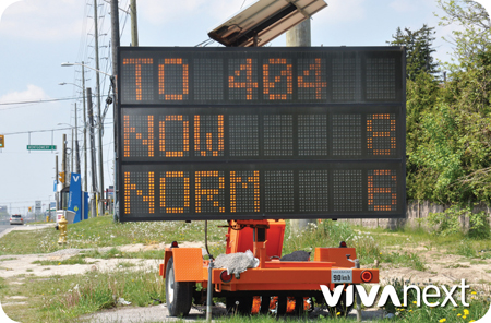
We’ve all seen them at one time or another, the big orange and black electronic message boards relaying construction information and how long it will take to travel through a construction zone. You may have asked yourself how these signs provide up-to-date travel time and are they accurate? Perhaps you even timed it to test its accuracy.

These signs are Variable Messaging Signs [VMS]. You may have also heard them referred to as construction message boards. You will see them posted at key locations along the vivaNext rapidway corridors currently under construction. The signs operate from a bank of batteries. Energy from the sun, collected by solar panels on the top of the sign, recharges the batteries allowing the construction information and real-time travel information to stay lit.

The real-time travel information works from innovative Bluetooth technology based sensors to calculate travel times through the construction zone. Once a minute, the current average travel time is posted to the VMS. We were the first in North America to track Bluetooth data and convert it into real-time travel time displays to help commuters decide the best way to minimize their travel time through construction.

So how accurate is the real-time travel data on these signs? We keep a close eye on the travel times displayed on the VMS. We continuously monitor and check the accuracy of these signs to ensure the travel times provided are precisely the time it takes to travel through the construction.

The VMS are just one example of the tools and technology we use to keep you informed of rapidway construction. Check out vivanext.com for the latest news and if you haven’t already, sign up for construction updates.

We thank you for your patience during vivaNext rapidway construction. Once the transformation is complete, the rapidways will help connect communities, save people travel time on viva and transform the physical look and feel of the streets to be beautiful refreshed places to visit, shop or work.


Categories
Construction General Live-work-play Rapidways Uncategorized Urban Planning vivaNext.com

Finding the balance: maximizing construction while minimizing inconvenience


If you’ve ever been involved in a home renovation project then you know it’s far easier to work in a room that is empty or unused, rather than the high traffic rooms, like a kitchen or bathroom. It’s one of the biggest challenges vivaNext faces during the rapidway construction – how to work in a confined, busy space that’s open for business 24/7.

Building a roadway is a process that follows clearly defined steps and uses modern technology, equipment and materials.  In York Region, we are fortunate to have access to some of the best, most experienced construction contractors anywhere, so building the rapidways is – in some ways – a very straightforward project.  Straightforward, that is, until you realize that the rapidways are being built down the middle of some of the Region’s busiest roads.  So during construction, it’s critical to minimize the impact on people using the roadway by keeping travel lanes open during construction whenever possible.  This is where “construction staging” – the process of doing the work in specific phases or steps to manage within the available space and right-of-way [ROW] or easement comes in.

Construction needs to happen in its own separate space; excavators need to swing their buckets, concrete trucks need to make deliveries, and construction trucks need room to back up. For this reason, the first step in rebuilding one of these busy roads is to create some extra room for construction crews to work safely.  The best approach to do this is to take out the median, narrow each of the lanes and shift them over by repainting the lines. This way crews can work in the extra space that’s been freed up, before moving to the next.

Think of our kitchen example – it’s like putting down a new floor – you do one side, and then move your fridge and stove over to the completed side so you can do the other half. Once one section of construction is done, lanes are repainted again to shift them back, and begin work on the other side, working in stages along the entire segment.

To help manage the work areas, the Region also takes temporary and/or permanent easements or ROW’s on properties that are within York Region Rapid Transit’s construction limits. This ensures that when it’s time for a certain stage of construction the area is clear and available, permitting crews access during construction at any time. Easement areas include boulevards, sidewalks, driveways and parking lots fronting the rapidway construction. Rest assured, during construction, the vivaNext teams are committed to minimizing disruption, maintaining driveway access and keeping a sidewalk open at all times.

Sometimes you may even get the feeling that we’ve returned to an area even though it seemed like we were finished. It’s not déjà vu, what you’re actually seeing is our staging technique, where work is done in small, careful steps.

And just as you wouldn’t be able to live without your kitchen while you renovate, we will keep the roads open during construction, relying on staging to minimize the impact of work in order to finish as quickly as possible.  We thank you for your patience and hope you are following along as this amazing transformation unfolds.