Categories
Communications Construction Rapidways Stations Uncategorized Video

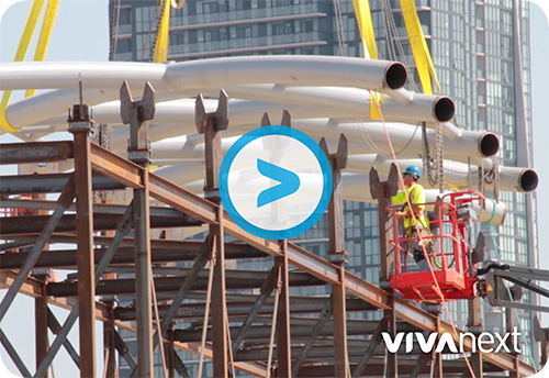
the ballet of building the VMC canopy

Vaughan Metropolitan Centre – Spadina Subway Station

The giant sections of structural steel canopy were installed this fall in the Vaughan Metropolitan Centre [VMC] area – right in the middle of Highway 7 West – and it was a ballet of precision.

Having a large structure like this arise in the centre of a roadway is an incredibly unique construction event.

That’s why we made sure we were out on the corridor watching and recording the action to share with all of you.

The largest section lifted was 25,000 lbs – over 11,300 kg! You can read more about this new Vivastation, and check out the video to see how this feat was done.


Questions or comments? Comment below or email us at contactus@vivanext.com. To stay up-to-date on construction, sign up for email updates at vivanext.com/subscribe.


Categories
Construction Rapidways Studies Technical

designing for the future

Who can remember? Not so long ago Highway 7 in Markham and Richmond Hill was a suburban highway: a few isolated developments, lots of parking lots and open fields, but no sidewalks, no plantings, no bike lanes–and certainly no dedicated rapid transit bus lanes. Just look at it now!

In only a few years from start to finish, construction begins and is completed on each of the rapidway projects. In the world of infrastructure renewal, vivaNext construction projects are known to be implemented very efficiently, and we’re doing everything we can to maintain that great reputation.

years of work are behind the design

What’s not so apparent to the public is the lengthy design process that happens long before construction starts. Design of the many engineering and architectural elements must take place stage by stage. Throughout, the designers need to balance staying true to the original vision with making it work in different conditions and geographical areas.

a variety of disciplines at work

VivaNext uses a multi-disciplined design team including: engineers who specialize in civil, traffic, structural, geotechnical, electrical and transit systems; architects; environmental consultants; landscape architects, security experts and more.

many stakeholders weigh in

At each stage, different options and features are reviewed, adjusted and improved with input from municipal staff, utility companies, local conservation authorities, property owners and others. Depending on the location of the project, specific design issues are addressed in conjunction with the owners of adjacent infrastructure including GO Transit, 407 ETR, CN, and the Ontario Ministry of Transportation.

the stages of each project

The process is not a fast one; the Environmental Assessment process, which established the conceptual design for vivaNext, was begun in 2002, and the whole process for any one segment from Preliminary Engineering to service start may take 6 or more years. Here’s an overview of the stages each of our projects go through, before shovels can hit the ground.

•    Environmental Assessment [EA]: The EA examines alternatives and identifies a preferred design. The vivaNext conceptual design shows the approach for individual segments like the number of rapidway and traffic lanes, boulevards and planting zones and the arrangement of stops and stations. The EA then identifies potential design impacts on the natural and built environment, traffic, noise, drainage, property, etc., and proposed strategies to avoid or mitigate and monitor them.

•    Preliminary Design: This stage takes design to approximately 30% completion and establishes the outlines of the project including its alignment and profile, what additional property is needed to build the project, development of major components like bridges or culverts for water crossings, entrances and intersections, utilities, and listing permits and approvals.

•    Detail Design: This stage fleshes out the preliminary design for all elements. For example, preliminary design may identify that a high retaining wall will be needed at a specific location; 60% design will show the kind of foundation needed and the wall’s general construction; 90% design will show the colour and design of the material to be used on the outside of the wall, and 100% will show all details and specifications required to construct the work.

•    Issued-for-Construction Drawings: These are the final design drawings to be used by the contractors, once all approvals are complete.

By the time vivaNext is complete, all our projects will share the original design vision, but their individual design will reflect local requirements and various conditions. Each segment is tailor-made to be functional, convenient and beautiful, with the primary goal of providing a rapid transit system for the future. Which is, and always has been, the ultimate vivaNext design objective.

Categories
Construction Rapidways Stations

form meets function where Viva meets the subway

form meets function where Viva meets the subway

There’s a lot happening near Highway 7 and Jane Street right now. With the subway extension, bus rapidway, bus terminal, and commercial and residential buildings being built, it’s difficult to distinguish one construction project from the other. In the past week though, one project has become more visible.

In the middle of Highway 7, between Jane Street and the Highway 400 ramps, a huge structure is being built. The VMC-Spadina Subway vivastation will play an important part of this transit-oriented area, connecting Viva customers to the subway below.

The station is supersized with longer and wider platforms, and the roof will cover the entire rapidway. Customers will be able to access the concourse below via elevator or stairs to access the new subway extension or walk a few minutes underground to catch YRT or Züm at a new bus terminal.

A few fun facts about the station:

  • Single canopy is 50m long x 22m wide – bigger than the other vivastations to accommodate more bus and passenger traffic.
  • Steel structure assembled as three roof sections [now installed]; eight ladder sections [the first just arrived]; and 70 smaller infill sections.
  • Uses a combination of aluminum, painted steel, ceramic frit and tinted glass panels – overall, the station will appear light grey with blue and white accents.
  • Up-lighting will illuminate the lattice pattern of steel supports and glass panels on the roof.
  • Real-time bus arrival screens in station waiting areas, and underground at concourse level.
  • Heated and unheated waiting areas on each platform.
  • 100% coverage by security cameras.
  • Windscreens to block the prevailing wind – potential showcases for public art.
  • Hidden rainwater gutters and downspouts to drain water under the roadway.

The steel structure can be seen in the middle of Highway 7, and this will take a couple of months to put into position, and another couple of months of welding. As you’ll soon see, this station will make the Vaughan Metropolitan Centre area look very different. And once it opens in 2018, will connect everyone to where they need to go.


Categories
Construction General

what’s in a sign?

What’s in a sign?

Even with the most careful planning, construction zones pretty much always result in some delays and congestion for commuters, and we know that our vivaNext rapidway projects are no exception. We are committed to doing whatever can be done to minimize the impact of construction and keep people informed.

One way of doing that is to let drivers know if there’s congestion along their route, and if so, how much of a delay they can expect. By giving real-time information, drivers can decide if they should take an alternate route.

That’s why we install variable message signs, or VMS, on the approaches to our construction zones, including along Yonge Street and on Highway 7 near the Vaughan Metropolitan Centre.

Using Bluetooth Traffic Monitoring [BTM] software, these signs show actual travel times, in real time, between specific locations. Roadside sensors collect Bluetooth data from passing cars, and the information is uploaded to a central location. The software then analyzes the data to determine current travel times, which is reflected on the signs. In addition to travel time, project managers can update other information on the signs, such as upcoming work or lane closures.

BTM is able to detect Bluetooth signals emitted from cell phones, tablets and other Bluetooth or Wi-Fi devices on-board, and convert this into accurate information, simply and inexpensively. Not all vehicles carry devices with Bluetooth turned on, but there is a high enough proportion of devices to provide effective information.

Cars emitting Bluetooth signals are randomly chosen as they pass into the defined area.  Multiple sensors placed along the route detect the unique identifier of each Bluetooth signal and track it as it travels through the area. In this way, the system measures in real time how quickly cars are moving, and reports actual travel times. The software has built-in algorithms to make sure it only tracks vehicles while ignoring Bluetooth signals emitted from pedestrians or other stray sources. The information is constantly uploaded to the VMS, telling drivers exactly what’s happening on the route ahead.

The technology to use Bluetooth data to analyze travel times has been around for some time.  But vivaNext was actually the first project in North America and possibly the world, to collect and convert this information for display on variable message signs.

What’s in a sign? We know that the signs on their own won’t reduce the disruptions caused by construction. But by providing drivers with accurate travel time information, they’ll know what to expect for their commute.


Categories
Live-work-play Urban Planning

going where the action is

going where the action is

In York Region, there are over 120 bus routes travelled by Viva and YRT buses, and some are busier than others. Some of the busiest routes are on Yonge, Highway 7, Bathurst and Centre Streets, Bayview Avenue and Leslie Street. If you live or work in York Region, there’s a good chance that you travel one of these roads regularly, so it’s no surprise that other people want to go there too.

When building transit, planners have a few goals in mind: ensure most people have access to transportation; have transit where people want to get on and off; and be prepared for future growth and development.

Ensuring most people have access to transportation allows people to get where they want to go, even if they have a specific need or live in a less populated area. In York Region, Dial-a-Ride, community buses and seasonal services [like Canada’s Wonderland!] are examples of this. Community buses take people to places where there’s a special interest, like hospitals, plazas and schools.

The most popular transit routes go where people want to get on and off. People want to go where the action is, so routes are planned where shopping, services, jobs, and higher-density housing is already along the way. One example of this is the area around Bathurst and Centre Streets, where shops and amenities are walking distance to a transit terminal and multi-story condo buildings. Connections to other transit are a big draw too – so routes are planned near bus terminals, GO stations, and future subway stations.

In some cases, we’re preparing for future growth by building transit before development. Enterprise Boulevard in Markham is a planned downtown area near the Unionville GO Train Station that only seven years ago was mostly vacant fields. We opened the first segment of rapidway there in 2011, and since then condo buildings, a sports facility, shops, restaurants and entertainment have all been built, and hotels and a York University campus are on the way.

Whether development is already there or on the way, transit planning means making sure transit is easy to access, and goes where people want to go – an important element in building great communities.


Categories
Rapidways Urban Planning

New book on ‘complete streets’ highlights the Highway 7 East vivaNext project

New book on ‘complete streets’ highlights the Highway 7 East vivaNext project

The Toronto Centre for Active Transportation [TCAT] has recently published a book on street-transformation projects, called: Complete Street Transformations in the Greater Golden Horseshoe. One of the projects they featured is the vivaNext rapidway on Highway 7 East in Markham and Richmond Hill!

The book includes nine different street-transformation projects from southern Ontario that, according to TCAT, “involved redesigning streets to make more space for one or more of pedestrians, cyclists, or transit riders.”

They also present outputs and outcomes of each project. For the Highway 7 East project, they comment on the safety improvement brought by the transformation, the increase in pedestrians and have included a cyclist and pedestrian count in one segment of the street. And, of course, they also note the improvement in transit travel times, with the BRT shortening the average transit rider’s commute by over 30%.

The most recent edition of Novae Res Urbis (GTA), the urban planning magazine, promoted Complete Street Transformations and said this about the vivaNext project:

“By far the most ambitious project highlighted in the book was the $308-million transformation of Highway 7 East in the City of Markham and Town of Richmond Hill. The former provincial highway was transformed into a multi-modal transportation corridor with bicycle lanes and a dedicated transitway. The result was a dramatic increase in the number of pedestrians, cyclists and transit users in the corridor, as well as a 64 per cent reduction in collisions.”

You can download a copy of the book here. The good stuff about the Highway 7 East project starts on Page 11!

Questions or comments? Comment below or email us at contactus@vivanext.com. To stay up-to-date on construction, sign up for email updates at vivanext.com/subscribe.


Categories
Rapidways Safety

rapidways >> who goes there?

rapidways >> who goes there?

We have rapidways open on Highway 7 East, and on Davis Drive, and most people who live and work near these new rapid transit routes know who has access to the rapidways – buses! In fact, the rapidways are paved in red and painted with “bus only” to prevent others from accidentally entering the lanes.

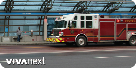
There are a few others who are allowed to drive in the rapidway lanes. Ambulances, fire engines and police cruisers are permitted in an emergency to get past traffic quickly and safely. This is an added benefit that the rapidways bring to each community – saving valuable time when it’s truly needed.

Vehicles such as snow plows and street cleaners maintain the rapidways as needed. Maintenance and security staff from YRT/Viva operations and their contractor, TOK Transit, also access the rapidway stations and their marked vehicles may be seen at the far end of a station platform. This part of the platform is ramped on one side for their use – but this ramp should never be used by regular traffic to cross the rapidway.

Pedestrians and cyclists have access to any vivastation via the traffic signals and crosswalk, but should never jaywalk or cycle across or along rapidway lanes. To do this is risky because it’s unexpected and distracting to both Viva operators and drivers in regular traffic. And although we fully support active and alternative modes of travel, you also can’t travel the rapidway lanes in a scooter or wheelchair, skateboard, motorcycle, hoverboard, segway, golf cart, unicycle… or any other interesting mode of transportation we haven’t thought of yet!

You may wonder why Viva buses use the rapidways, but YRT buses don’t. The reason is that YRT buses either need to turn on and off the road frequently to gather customers, or their purpose is different – e.g., more stops, turning into shopping plazas, etc. Viva and YRT routes are evaluated by YRT/Viva’s Service Planning branch on a regular basis, and service changes are made to routes and schedules as needed.

A street that includes a rapidway is a complete street, with space for doing everything in a safe and efficient way.  Hope you get out and enjoy our streets this spring!


Categories
Construction

the CN Bridge is bigger and better than ever

the CN Bridge is bigger and better than ever

Highway 7 West is changing quickly, with beautiful new sidewalks, tree planters and vivastations at Creditstone and Keele. Rapid transit is on the way to Vaughan, but it’s about more than just transit. Once the rapidway projects are complete, new infrastructure will be in place, including utilities and bridges.

crossing the bridge

One bridge that cannot be missed is the CN MacMillan Bridge, crossing over the largest rail yard in Canada. The MacMillan Yard was established in the 1950s and is named after one of CN’s founders, Norman John MacMillan. The yard operates 24 hours a day and handles over a million train cars per year.

bigger and better

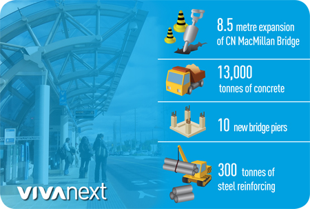
As part of widening Highway 7, the CN MacMillan Bridge needed to be expanded a total of 8.5 metres on the south and north side. This involved rebuilding the underlying structure with 8,000 tonnes of backfill, 10 new vertical piers, and 18,000 tonnes of steel reinforcing 13,000 tonnes of cement, and laying a new road surface – all without disrupting CN rail operations below!

better for people too

The new bridge will have two new rapidway lanes, but it’s not just for driving. Pedestrians and cyclists will be able to enjoy the view as they cross on the improved sidewalks and a bike lane.

If you’re driving on the bridge in the coming weeks, you may notice the lanes being reconfigured, and a crane being “walked” from one side of the road to the other.

Once the rapidway project and the subway extension are done, this major transportation hub will be transformed for any mode of travel – rail, bus, and subway.


Categories
Construction Going Green Rapidways Uncategorized

3 ways function will meet beauty this year on Highway 7 West

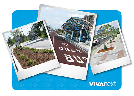
Greenery red pavement paver stones

There is always a point in time every January when it seems like the bitter wind and frozen ground will never give way to gentle breezes and fresh green grass.

If you’re having one of those moments, here are three things to look forward to this year, after winter is over – in particular, three features of the rapidway project that match function with beauty.

Here are three functional, attractive developments you will see happen on Highway 7 West in 2016:

1. Sidewalks, beautiful sidewalks

Want to be the first person to ever walk on sidewalk on Highway 7 all the way from Jane Street to Keele Street? This is the year you’ll be able to do so, for the first time in Highway 7’s history. Those sidewalks will also be beautiful to walk on, with gorgeous paver stones. If you need to look at a sample of what’s to come, you can check out the already installed sidewalk on the north side of Highway 7 between Jane and Creditstone, along Highway 7 East in Markham, and on Davis Drive in Newmarket.

2. Greenery

Concrete planter boxes are being constructed in the centre of the rapidway and along the sidewalks. This spring, they will be filled with nutrient-rich soil and planted with a carefully curated selection of trees, bushes and plants. Highway 7 West will turn green!

3. The iconic red pavement

This is the year you’ll get to see that glorious red asphalt appear along the newest rapidway on Highway 7. Suffice to say, we get very excited about seeing this roll out, because it delineates the rapidway and because it looks so darn great. Once again, function meets beauty.

If you’d like to subscribe to email updates about the progress of the vivaNext project on Highway 7 West in Vaughan, click on this subscriber link, or go to our homepage at vivaNext.com and scroll down to “subscribe”.

Categories
Video

what’s behind the numbers on Highway 7 West

click here to see the video: fun facts - vivaNext in Vaughan

It’s been a busy year along Highway 7 in Vaughan. We thought you’d like to see a glimpse at some of what’s been accomplished in 2015 and a few snapshots of what’s to come.

In this video, you can check out some of the stages of work behind road widening, vivastation canopy creation (in case you weren’t driving by while it was happening), the expansion of the CN MacMillan Bridge, a whole host of retaining walls – plus a whole lot of greenery to be planted in the spring.

There are “tonnes” of information and stories behind the fun facts on Highway 7 in Vaughan!

Click here to subscribe to email updates about the progress of the vivaNext project.