Categories
General Urban Planning

The power of development

What’s the significance of a pole? In the past few years some of York Region’s towns and cities have been talking about whether or not to bury hydro lines. We’re designing and building rapidways in key urban areas, so naturally the topic of hydro poles and lines comes up when we bring forward new pedestrian-friendly, attractive streetscapes.

Understandably, most people would like hydro lines to be buried, rather than hung from hydro poles. Burying hydro lines is a major project though, and so deserves careful consideration. The cost of relocating lines underground all at once can be up to 10 times the cost of keeping them above ground. That’s not to say that it isn’t worth the money, but it is a big investment.

We support municipalities in their efforts to bury hydro lines, and we also understand why it can’t always be done all at once. Most urban planners agree that hydro poles can be buried over time as a natural result of development and growth, and this is how it could happen:

  • We build rapid transit in key growth areas, attracting people to the added convenience and pedestrian-friendly environment.
  • Where there are people moving in, there will likely be development.
  • When developers build new buildings, hydro lines are often buried as part of the project, either by their own choice or by local zoning regulations.

Regardless of whether hydro poles are buried or not, we’re designing modern streetscapes along the viva corridors. Where hydro poles are being replaced as part of our rapidway projects, we make poles as attractive as possible using special finishes and features. In some cases we use poles that don’t need guy wires, and higher poles to minimize the appearance of the wires. Wherever possible, we bury telecommunications and fibre lines, reducing the number of wires on new hydro poles.

Urban planning is full of important decisions, and the rapidway designs include innovative ideas, while building great neighbourhoods for future generations.

Categories
Urban Planning

Let’s talk transit

I was recently watching a video about the importance of transit in communities [see the link below], and was reminded what a difference it makes to every person to have convenient, fast transit nearby. Those of you who take transit every day are likely nodding as you read this, but if you’re not a regular transit user you may wonder how it can benefit you.

If you have to drive every day, then the road in front of you has one less car for every person who takes transit. It may be hard to picture, but next time you drive down an urban street, imagine that the people driving cars around you are riding transit and waiting at transit stops instead.

Transit is important to people with different incomes, and at different stages of life. Not only is it a smart way to save money, sometimes it’s the only affordable option to get to school or work. Having the option to take transit can be liberating, especially if you’re unable to drive due to age, medical conditions or disabilities. Some may use transit mostly in their youth, whereas others may find themselves using it later in life.  The wonderful thing is having choices.

Where you live plays an important role too. Transit is more popular in urban areas where driving and parking are frustrating. If you live just outside an urban area, transit can be your ticket to town, without having to pay for parking or taxis.

So as the video says, transit is important for communities – and that includes you, those you live with, neighbours and coworkers.

Video by the Canadian Urban Transit Association: youtu.be/HQtYFVNU7XQ

[poll id=”40″]

Categories
Urban Planning

Designing a complete street for everyone

the Complete Street

VivaNext is of course a project to bring rapid transit to York Region. But our goals are much broader than simply expanding transit (as important as that is for us): our long-term vision is to help York Region, as it grows, to transform beautifully from its suburban past, into its urbanized future.

When I think about the most livable cities of the world, including here in North America as well as in Europe, one feature that makes them distinctive is the way major streets are designed for everyone, and not just for cars.

This approach is captured by the urban design concept known as “the complete street.” That’s the long-standing philosophy behind European urban design, but it is also becoming very influential in North American urban design. The complete street reflects a belief that streets should anticipate and accommodate the needs of all users – pedestrians, transportation users, cyclists and drivers. It means that streetscapes should be designed to provide a welcoming, functional and safe environment for everyone, no matter how they want to get from A to B.

The complete street concept is consistent with York Region’s vision for its urbanized future, especially along its major corridors and emerging urban centres. So the vivaNext streetscape design principles reflect similar values and priorities.

As our work progresses along the Highway 7 rapidway, it’s becoming easier to see how these design principles are going to transform the look and function of the street and its boulevards, for all users.

To begin with, our streetscape design emphasizes the importance of having an attractive public realm, to encourage people to want to spend time in these newly developed public spaces. By offering wide boulevards, with their attractive paving, good lighting, shade trees, amenities such as comfortable benches and generously planted landscaped areas, pedestrians will know that they are truly welcome.

With York Region’s predicted growth, there will be many more people living, working and commuting all along our major corridors, meaning many more pedestrians will be using the sidewalks and intersections. So our streetscape is designed to make everyone truly feel safe and comfortable – after all, Highway 7 and York Region’s other major corridors will continue to be very busy thoroughfares for other vehicles, even once our rapid transit system is up and running. Pedestrians will feel buffered from adjacent traffic by the wide planters placed between the sidewalk and curb. They will have protected places to wait at intersections, and in the median where there are two-stage crossings. All sidewalks and vivastations will be completely accessible. And cyclists will have safe places to ride, and convenient racks to lock up their bikes.

By creating a complete street, our new streetscapes will be walkable, accessible and welcoming for all, no matter how you prefer to get around York Region.

Categories
General Live-work-play

The vivaNext generation

Construction on vivaNext projects is moving full speed ahead. As structures are built and roads are widened, visions of the future are becoming a reality. The promise of the next generation of York Region’s rapid transit is coming to life.

Here at the vivaNext office, we have also welcomed a next generation, with two new summer students joining our communications team. They both have grown up in York Region, one hailing from Newmarket while the other is from Vaughan. Each of them has lived in the Region for over twenty years, so they know how it has changed over time. Both are looking forward to being a part of the team that brings York Region into its next era.

I hope that excitement like this spreads to all generations. I see the vivaNext generation as people of all ages, who use the vivaNext transit system as a way to travel to modern, urban destinations inside and outside of York Region.

For people in Vaughan, the Vaughan Metropolitan Centre (or VMC) will be a new downtown. As a hub for transit, business, shopping, and recreation, the VMC will offer a site for all ages to come together and experience York Region. Our summer student, Alanna, mentioned that she is thrilled about the opportunity to have a “downtown experience” closer to home.

John, our summer student from Newmarket, is looking forward to a highly improved Davis Drive for York Region residents. With pedestrian-friendly boulevards and easy access to places to shop, work, and relax, Davis Drive will become a new destination for the next generation of vivaNext travellers.  

Taken together, these individual projects connect into the vivaNext plan for a seamless rapid transit network, making it easy to travel to work, shopping destinations, and recreation.  

Our projects will benefit everyone who lives or works in York Region, and we want to keep in touch with all of you as these projects are underway. We’re making sure residents are in-the-know with our constant social media updates Be sure to follow us on Twitter and Facebook, and sign up for our e-mail updates.

The future is bright, and the vivaNext generation of travellers has a lot to be excited about.

[poll id=”31″]

Categories
Rapidways Uncategorized Urban Planning

A turn for the better: navigating the new traffic signals

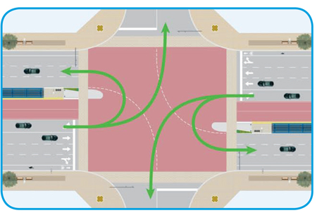
Intersection traffic patterns on Highway 7If you’re like me, traffic signals are one of those things that you automatically respond to without spending a lot of time thinking about them – if a light’s green it means you can go, and if it’s red you can’t. But when something is new, sometimes it helps to understand the reasons behind it. We’ve introduced new traffic signals on Highway 7 at the Leslie and West and East Beaver Creek intersections in December 2011, and want everyone to understand why they’re there and how they work.

As part of the vivaNext plan, rapidway lanes are being built in the middle of the road, making it much wider than it was in the past. The widening for this section of Highway 7 is now complete, so we’ve installed the new traffic signals at three of the intersections.

The new traffic signals include a protected left-turn arrow, which only allows left turns from Highway 7 when the left-turn arrow is green. During the left-turn arrow signal, there is no straight-through traffic in either direction and no pedestrian crossings allowed.

The reason for installing the protected left turn arrow is because of the increased width in the road. With the rapidway running down the middle of the intersection, the left turn lanes aren’t opposite each other.  The protected left-turn arrow allows left-turning traffic to turn without the hazard of oncoming traffic.

When the protected left-turn arrow is lit, drivers in the left-turn lane can also make a u-turn in the intersection. In sections of road with rapidway lanes in the centre, drivers will access addresses or streets on the opposite side of the road by making a u-turn at an intersection. Intersections with the new traffic signals have a special “U-Turn Permitted” sign under the “Left Turn Signal” sign.

During construction, video detectors will sense traffic in the dedicated left-turn lanes and extend the duration of the left-turn arrow. Once construction is complete, a magnetic sensor known as a “loop” will be installed in the pavement to detect traffic and extend the left-turn arrow duration.
At times, it might take a bit longer to drive through an intersection that has the protected left-turn arrow, but overall, our corridors are changing for the better. As our population grows, Highway 7 will become increasingly urbanized (see our blog about how Highway 7 is changing), and Yonge Street and Davis Drive will follow, each with their own local character. Instead of feeling like highways designed for cars, each street will feel like an urban area, with interesting destinations. The new traffic signals will be there to ensure drivers and pedestrians can navigate safely to their destination.

Diagrams of intersection traffic patterns:
Six-lane road, like Highway 7
Four-lane road, like Davis Drive

Diagrams of u-turn traffic patterns:
Six-lane road, like Highway 7
Four-lane road, like Davis Drive

Categories
Construction Going Green Urban Planning

New technology takes root: helping trees grow

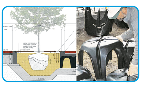
Diagram and photo of Cupolex

Among the beautiful benefits of the vivaNext project will be the improvements we’re going to make to the streetscape along York Region’s key corridors. A key part of those improvements will be carefully planned landscaping, including street trees planted at regular intervals for beauty and shade. Ensuring those trees survive in a tough urban environment is always a challenge, which is where science and technology come in.

Fortunately, our Landscape Architects are up to the challenge, and have tricks up their sleeves to keep our trees healthy and growing strong. To begin with, choosing the right tree is critical. Street trees, especially ones along roads carrying a lot of fast-moving traffic, need to be the kind that can stand up to salt spray and pollution from vehicles. Street trees also need to be relatively drought tolerant, and able to thrive without daily maintenance.

To meet these needs, our Arborist and Landscape Architects focused on a range of hardy trees, including different types of gingko, oak, maple, common hackberry, Kentucky coffee tree, ornamental pear and elm.

Once they’d solved the issue of which trees to plant, Landscape Architects turned to the other big problem facing urban plantings: large trees need a lot of soil around their roots. In a boulevard, there’s only so much room for soil, so trees generally don’t have the underground space they need to grow strong roots and take in nutrients. Our team is using an ingenious solution called “soil cell technology.” This refers to the cutting-edge approach of constructing a rigid form underground that can be filled with soil and then covered up by sidewalks or even roads.

Our soil cell technology is called Cupolex®, and was originally designed as a technique to provide a solid underground framework for ductwork and cables. At first glance it looks like a plastic patio table, with hollow legs at each corner. A series of these patio tables are installed underground, with their legs interlocking, forming a large honeycomb shape – a soil cell – surrounding where the tree will be planted. Then concrete is poured into the legs and over the top, creating a hard, self-supporting shell strong enough to support the weight of vehicles. The boulevard and sidewalks are constructed right over top, with openings left for planting trees. Special access hatches and irrigation pipes are installed for future tree maintenance, and then nutrient-rich soil is blown in, and trees are planted in the openings.

We’re not talking a regularly sized planter full of soil: each soil cell holds at least 16 cubic metres of soil. And each cubic metre is about the size of a stove, so imagine 16 stoves worth of soil for each tree! A typical dump truck holds 8-10 cubic metres, so each tree is going to get more than a dump truck of soil. That’s a lot of soil, and it’s really going to help our trees’ survivability.

Our vivaNext pledge is to do the best planning now, for a beautiful and functional rapid transit system and streetscape. Creating healthy, strong trees that can be enjoyed for generations is part of that, and it’s something we can all be proud of.

Categories
Urban Planning

Bus Rapid Transit: South America leads the way

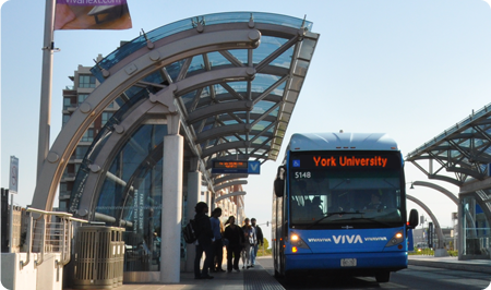
Inside a BRT station in Curitiba – photo by www.ThomasLockeHobbs.com

The vivaNext rapidways project is one of a relatively small number of Bus Rapid Transit projects here in Canada, or for that matter in North America. There are BRT systems in Canada and the US, but the number of cities with BRT systems planned is relatively small, compared to the number of cities that would benefit from better transit.

What’s really interesting is how many cities around the world use BRT – cities with enormous populations and transit usage. Transit experts at EMBARQ (the Sustainable Transport wing of the World Resources Institute, an environmental think tank) estimate there are 120 cities around the world with BRT systems. And South America has taken to BRT enthusiastically, with BRT systems in 32 cities – more than a quarter of the total BRT systems around the globe.

One of the earliest BRT systems in the world was built in Curitiba, a large city in the south of Brazil with a population of just under 2 million within a larger metropolitan area. Other systems have been built all over South and Central America, including in all the major cities like Guatemala City, São Paolo, and Bogotá. There’s no doubt those systems are a spectacular success – transit ridership numbers in South American cities are huge. The Curitiba system carries a whopping 2.3 million riders per day, using 72 kilometres of median bus rapidway. Or how about São Paulo, with 104 kilometres of bus lanes, and a daily ridership of 5.7 million!

Besides a convenient way to get around, cities with bus rapid transit have been shown to have reduced commute times, lower tailpipe emissions and fewer traffic fatalities. And a key part of the success of these successful systems is that transit was built early on, and the surrounding land use was shaped by rapid transit. People became accustomed to taking transit, and transit-oriented development followed.

It’s exciting to think of the benefits vivaNext rapid transit projects will bring to our region. We know that there are differences in climate, landscape, and culture between South and Central American cities and York Region, but there are examples of BRT elsewhere in the world, and I’ll talk more about those next week.

Categories
General Rapidways

A hum of activity

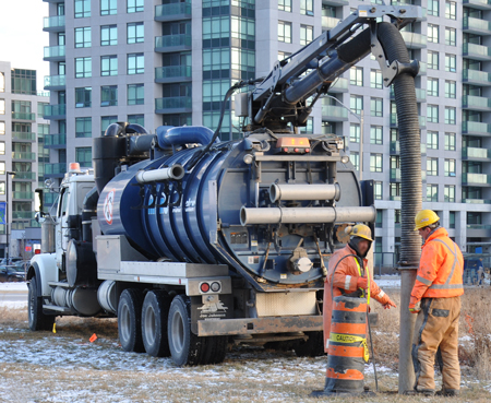
Photo of hydrovac preparing for utility relocation
Hydrovac crew bores a hole in the ground

There has been a hum of activity on Highway 7 lately. To be specific, the hum of a hydrovac – a large truck-mounted vacuum used to bore holes in the ground. We’re widening some of York Region’s roads to add dedicated rapidway lanes, but to do that we need to locate utility cables and pipes in the ground, and then use a variety of trucks and tools to move all of the utilities further back from the roads.

In terms of utilities, all roads are not the same. Which utilities are in place, where they are placed, and who is responsible for them varies for each section of each road. Electrical power lines and telecommunication wires are often located aboveground on poles, but sometimes they’re buried underground. Gas lines, and sewer and water main pipes are also underground, but not necessarily located together.

In many cases, the utilities need to be moved in a certain order to spots designated by York Region’s Transportation Services Department, Corridor Approvals and Records Branch with input from the construction company. This branch ensures utilities are installed in appropriate locations and keeps record of utility locations. Each organization moves their own utilities and, while doing so, uses the opportunity to check over the equipment or upgrade it.

Municipal government is usually responsible for sewer and water main pipes, but a team effort is important in cases where they cross municipal boundaries. For example, the intersection of Highway 7 and Yonge Street includes land within the Town of Markham, the Town of Richmond Hill, and the City of Vaughan. Gas, electricity and telecommunication companies also vary depending on the location. At vivaNext we work with all of these stakeholders to accommodate schedules and procedures, ensuring we reach our goal of relocating utilities in time for the next scheduled construction activity.

Categories
Rapidways Stations Urban Planning

Finding your way from here to there

vivaNext - rapid transit this wayFor those of you who enjoy video or computer games (or for those who are of “a certain age” but have kids who like gaming), you may be familiar with the variety of games that involve being lost in a maze…you know the ones. You need to figure out where you are and how to get to the end (complete the level!), before something bad happens or the clock runs out. Being lost in a confusing maze can be fun when it’s a game and you’re in a virtual world.

In the real world however, feeling confused and trying to figure out which way to go in a public space, whether you’re in a shopping mall, an airport, or a transit station, is a lot less fun. At the very least, you may waste a lot of time and effort. At the worst, you may miss your connection. Helping people to navigate easily around public spaces, and in a transit environment in particular, is a specialized form of urban design called wayfinding; it’s something we take very seriously in our planning for vivaNext projects.

Our wayfinding design work began quite some time ago, as part of the overall design work for the vivaNext rapidway stations. We have a diverse range of Viva riders – people of all ages, abilities and languages – so vivaNext wayfinding needs to go well beyond simple signage. Wayfinding systems can use a number of elements, from architectural space to maps to signage to graphics, to help people figure out how to get where they want to go, in a safe way. As we design our rapidway stations and station intersections, including the cross-walks and platform layout, we always consider how people will use the stations. We want to make it as easy as possible for people to know which station they’re at, where to buy tickets, and which platform they need to be on.

One of the best parts of the vivaNext plan is the impact our stations will have on making local neighbourhoods even more attractive, providing landscaped and welcoming public spaces. Wayfinding will play a role in linking the rapidway stations with their surroundings. Our design team is working on strategies to ensure each station provides information about local destinations and connections.

So if you’re looking for the thrill of being lost, you’ll have to stick to gaming. Our design work isn’t complete, but from what I’ve already seen, getting around on Viva via the rapidways will always be safe, easy and convenient.

Categories
Live-work-play Urban Planning

Building a bridge between the past and future

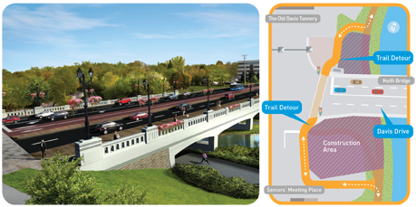
The future Keith Bridge on Davis Drive in Newmarket, and diagram of the Tom Taylor Trail detour

A sense of history and attractive landmarks can give us a feeling of stability and pride in where we live; making us even happier with the town and neighbourhood we live in. Voted one of the best places to live in Canada by MoneySense Magazine, Newmarket ranks 15 out of 179 Canadian communities.

People who call Newmarket home have discovered the heritage and scenic areas in the centre of town. The East Holland River is the historic backbone of Newmarket, flowing alongside historic Main Street, under the Keith Bridge on Davis Drive and north to Lake Simcoe. In the 1800s, Newmarket residents used the river for industry and irrigation. Today it’s used for recreation, following along the Tom Taylor Trail. Recently those using the trail have seen some detour signs where it normally passes under the Keith Bridge. The detour directs people to cross at the traffic lights on Davis Drive, and pick up the trail again on the other side.

Over the next year, we will be widening the Keith Bridge to allow for rapidways to be constructed on Davis Drive from Yonge to the Southlake Regional Health Centre. As we widen the bridge we’ll also be enhancing it, adding architectural features such as stonework, railings and light fixtures that provide interest and reflect Newmarket’s heritage.

Completing the beautiful new Keith Bridge by the end of 2011 is a major part of the Davis Drive transformation that Newmarket residents will be watching with excitement over the next three years.