Categories
Going Green Rapidways

Protecting the environment

Protecting the Environment

If you’re a regular reader of this blog, you’ve probably explored the vivaNext website and will have seen the information section on environmental assessments. But what that section doesn’t really describe, is why we do environmental assessments in general, and how they are done. So here is my version of Everything You Always Wanted to Know About Environmental Assessments.

To begin with, the premise of an environmental assessment is based on a really important principle: projects that are being built in a community (whether large, like a new power plant, or relatively small like a new street) must address any potential negative effects on the natural, social or structural environment. Equally important, is the requirement that the community – including all members of the public – be given opportunities to understand the planned project, what impacts it is likely to have and how those will be addressed, and to provide comments before the project is approved.

Our provincial and federal environmental assessment processes are the safety net that ensure a project has been carefully analyzed, and negative effects on the community are minimized. These environmental assessment processes also look at how a proposed project fits into a community’s plans for its future, to ensure it will enhance rather than interfere with a community’s vision for itself. Whether a project needs to go through the provincial process, the federal process, or both, depends on the type of project, the project proponent or owner, and the effects it will have.

All municipal infrastructure projects in Ontario are subject to environmental assessment under the Ontario Environmental Assessment Act. Depending on the type, complexity and potential effects of a project, it may be subject to one of the provincial environmental assessment processes, such as the Individual Environmental Assessment, Municipal Class Environmental Assessment or the new Transit Project Assessment Process, which now governs and expedites the environmental assessment and approval for transit projects. Although the steps and timelines differ for each type of provincial environmental assessment, all allow similar opportunities for the community and public agencies to comment on a project.

Each environmental assessment process involves evaluating a project to determine what impacts it will have, and how those impacts will be addressed. Impacts range from how the project will affect the natural environment (plants, wildlife, air, water and geography), to social effects such as increased noise and vibration, traffic impacts, and access to properties and businesses. Throughout the process, the public is consulted at prescribed stages. For instance, as part of the Transit Project Assessment Process, once the assessment has been completed and documented, it is made public for 30 days, during which anyone can review it and provide comments. At the final stage of the Transit Project Assessment Process, the Minister of the Environment has 35 days to either approve the project or require further work to be done. The entire process must take no more than six months.

Federal environmental assessments are done when a project may have an impact on an area within federal jurisdiction. For vivaNext projects, those areas are mostly related to navigable waters and fish habitat in rivers and creeks that will be crossed by our rapid transit lines. In the case of navigable waters, the intent is to make sure that our project will not have a significant effect on the public’s existing ability to access or use a waterway. An officer from the Navigable Waters office reviews our plans then literally comes and looks at all the watercourses our transit lines will cross, even the smallest creeks and streams, to see if either the roadway or any planned bridges will affect these waterways.

In the case of fisheries, we work closely with the local conservation authorities to assess whether the project will potentially harm fish habitats. In either case, if there is a chance that our project will have an impact, then a federal environmental assessment is required. Data collected during the provincial environmental assessment is used in the federal environmental assessment as far as possible to avoid duplication and a coordinated process has been developed to further improve efficiency. So far, the North Yonge Street corridor is the only Viva project that required a federal environmental assessment, which was completed on August 19, 2010.

Once the environmental assessment approvals are completed, we work closely with provincial and federal agencies, monitoring our projects to ensure we’ve lived up to our promises.
So as you can see, the entire environmental assessment process is a thorough and comprehensive one, as well as being totally transparent, to ensure the public knows what’s happening. I’d encourage you to read up on our vivaNext environmental assessments, and to also check out these links for more background information on the federal process and the provincial process:

Categories
General Rapidways

Engineering well so you won’t notice

Engineering Well So You Won't Notice

If you’ve ever come to one of our vivaNext open houses, you’ll be able to picture this scene: a room-full of long maps, blueprints and illustrations, showing all manner of lines, arrows and numbers. It’s not necessarily the most glamourous-looking stuff to many of us – in fact, some details can seem downright indecipherable! But to an engineer, these displays represent the product of months and months of immensely challenging puzzles, detailed analysis and problems to be solved.

Like other huge civil engineering projects, the vivaNext rapidways rely on an enormous amount of massively detailed planning; these details probably aren’t top-of-mind for the vast majority of people. When’s the last time you drove down a road in a rainstorm and paid attention to how well the water was draining off the roadway? Probably never. But I can guarantee that if the water was not draining well, you would notice. That’s the point of engineering – to anticipate and plan for a dizzying array of components,  in this case, the elements needed for roadway and transit system building – so that when the final project is built, everything works seamlessly and perfectly.

So what have those engineers (and architects) been doing for the last couple of years, anyway? Here’s a plain-language guide to vivaNext engineering.

Each week at the vivaNext office, our preliminary engineering team sits down and gives an update on all the project components they’ve been working on. Some items – like designing all the underpinnings (e.g. road grade, storm sewers and catch basins to make sure water drains properly) – are critical, but largely invisible. Some of the components require looking well into the future, for example, working with Regional and Town planners to anticipate future land use plans and potential developments to ensure intersections and stations are located where they will be most convenient and useful. Some of the planning is related to urban design issues, such as the kind of materials and finishes that will create the style of urban streetscape we want for our communities.

Did you ever stop to look at a street light pole? I confess that it never occurred to me what went into choosing a street light. I now know that there are many options for street lights out there, and someone actually has to spend time carefully considering what height, diameter, finish and shape will work and look best – not to mention what kind of foundations are needed, how they should be spaced, and what kind of light they will provide. Every decision point impacts the budget, how the streetscape will look and may impact the construction schedule as well.

And as with everything that involves public money, there is an ever-present (and totally appropriate) focus on getting the best value for money, and balancing design objectives with cost-consciousness. Some of these discussions involve items that I suspect many people would find interesting – like landscaping and street furniture choices. Other items deal with equally important but less visible questions (and let’s be honest, not terribly interesting for most people), for example, determining the best and most cost-effective way to protect all the electrical wires that will be buried under our rapidway stations.

Safety and legislated issues are key, of course – ensuring surfaces such as platform tiles aren’t slippery, and that stations and enclosures are accessible. Many questions – such as where to locate fare equipment and displays so people don’t have to go farther than necessary – involve anticipating how people will want to use the system and making sure it functions well. Some of the issues can draw on experience from other places – for example, understanding how wind and weather will interact with our glass canopies, so we can make them as comfortable as possible for riders. Others issues are totally dependent on finding made-at-home answers, by working with local municipalities, who in turn work with their stakeholders. These include things like fitting bike lanes into the roadway design, or how best to protect sensitive natural or heritage features.

One thing I have learned from observing our engineers at work, is how much careful thought, analysis and knowledge is required to build our vivaNext dream. For most – if not all – of the issues, there’s never an obvious answer. Every issue, from the most glamourous to the most prosaic, needs to be debated and weighed, with many different pros and cons considered and balanced. And everything is connected, so nothing is ever as simple or straightforward as you might think.

So next time you walk down the sidewalk or drive along Highway 7, give a thought to what you’re surrounded by, and notice all the little things that make up the streetscape –then consider the additional complexity involved in our vivaNext rapidway system! The effort is worth it to plan and build a vision, to make it work perfectly, and to get people around York Region easily, quickly and conveniently.

Categories
Announcements Rapidways Stations Subways

Dale’s summer update

Dale's Summer Update

Whew! What a busy few months we’ve had here at the vivaNext headquarters!  No doubt a lot of people have been enjoying this great summer weather and taking a bit of a break… but for those of us here, it’s been full steam ahead.  Since we announced the news this past May that Metrolinx approved a revised capital funding schedule for the vivaNext rapidways, our office has been a hive of activity! Okay, I took a week off as well to enjoy this summer weather.

But here’s an exclusive peek behind the scenes of what’s happening with vivaNext projects.

Although it’s not a typical rapidway station, our new stop currently under construction at Enterprise and Warden in Markham will be the first place you’ll be able to try out our new, comfortably designed vivastation.  The concrete foundations are currently being put in for the station, and sometime in early fall we expect to receive the glass canopy from the fabricators.  After all the work that went into designing it, we can’t wait to see the vivastation in person!  We’ll keep you updated on the delivery dates and let you know more about how you can see it too!

Our crews are out and about along Davis Drive in Newmarket, with most work presently focused on pre-construction activities in preparation for the road widening.  We’ve been taking down some existing buildings, and working closely with Habitat for Humanity York Region and other organizations to ensure that every last piece of building material that can be reused or recycled is diverted from landfill.  At least 85% of materials will be diverted – we are really proud of that. Even shrubs, plants and trees have been transplanted to new locations within Newmarket, including some churches and a public school.

Our engineers, architects and other experts are working hard on the preliminary engineering for the rapidways up Yonge Street and along Highway 7. Preliminary engineering is the early design stage of an infrastructure project, and it involves numerous hours of discussion and planning for options on things you may never think about when you drive down a street; things like median width, lightpole design and surface treatments.  Every step of their work is carried out in conjunction with a number of other partners, including The Regional Municipality of York and each of the municipalities, as well as other local groups. The amount of painstaking, detailed work that goes into designing a rapidway is just incredible – in a separate blog, I’ll tell you more about the processes, the challenges and introduce you to some of our experts.

We are also spending a lot of time working with our colleagues at the TTC on plans to connect the Spadina Subway extension to the vivaNext transit hub at Highway 7 in the Vaughan Metropolitan Centre.  Construction of a six-lane bridge, access roads, traffic signals, utility relocation and the realignment of a portion of Black Creek is now underway so that construction can start on the Highway 407 Station. This work is anticipated to be complete by spring 2011. Public open houses in July showcased the station design finishes and public artwork for the Sheppard West and Highway 407 Stations. More open houses will soon be held, so that the public can view the four remaining station designs. I hope to tell you more exciting details about the design ideas we’re working on in the near future.

Another key task that represents a huge amount of our efforts is the ongoing Environmental Assessment process – and rightly so: ensuring that our projects don’t negatively affect the environment, either natural or human, is a critical priority for this project.  Each rapidway segment has its own process and requirements – in fact, there’s so much to describe, I’m going to save it for another time!

During the summer we also participated in some fundraising events for United Way, attended several community events and participated in some local industry workshops.

So that was a brief summary of what we’ve been up to! We hope you’re enjoying the summer sunshine, and all of the great things there are to do in York Region!

Categories
Live-work-play Rapidways Urban Planning

Why “TOD” is great news for all of us

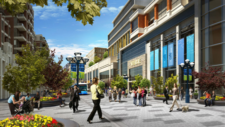
A rendering of transit-oriented development in Markham
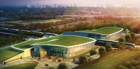
A rendering of transit-oriented development at the future Markham Centre

Recently, I wrote about transit and the role it has in shaping communities, in particular, the development that tends to spring up along transit routes and around stations. This time, I want to talk more about what we mean by “transit-oriented-development” ( TOD for short), and why this kind of development will be good news for people in York Region—whether or not they are transit users themselves.

Most people get around York Region by car – possibly because they want to – but also because some people find it challenging to do all the things they need to do in a day by transit. That’s not surprising in a region like this one; in communities where development has been shaped by a long-standing car culture, destinations are more likely to be spread out, with greater distances between live-work-play destinations. Even the design of buildings may be shaped by car usage, with large parking lots separating buildings from roads.

The idea behind TOD is that people using transit are also likely to be pedestrians at some point during their journey – either at the beginning, or the end (or both). Studies have shown that people are willing to walk about 5 minutes to or from transit, which is somewhere between 400 and 600 metres. So TOD uses the approach of creating a complete community within walking distance of transit – including workplaces, homes, shopping, recreation and services. The thinking is that if new developments are designed to be conveniently compact and appealing to pedestrians, people are more likely to leave their car at home for at least one of their trips. Obviously, the good news is that more people taking transit means fewer cars on the road, less pollution, and less gridlock.

So York Region planners have linked the plans for the vivaNext rapidways to land use policies that will result in more TOD along Viva routes and near vivastations. These policies will likely mean that much of the new development built around vivastations will be compact and mixed-use, providing housing, employment, retail, dining, services and recreation, all within a walkable distance of transit. Developments will also include more welcoming public spaces, attractive landscaping, and other amenities so that people enjoy being out and about.

How will this affect you? In a pre-TOD scenario, a typical day could start with a drive to work, then a drive to a restaurant for dinner, ending with a drive to a movie or concert before driving back home. With more TOD, you would have the choice of taking transit to work, then walking around the corner from the office to dinner, then strolling across the street for a show before grabbing a coffee and getting home again by transit. Same day, two different ways of getting around.

The point is that transit and TOD don’t have to change the way people live in York Region, but it will give us all more choices – in what we do, where we do it, and how we get there. We think that’s good news for everyone.

Categories
Rapidways

Rapidways just around the corner

enterprise-009_new

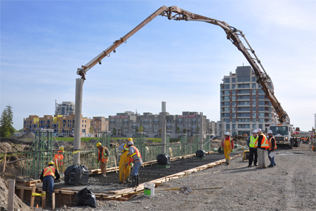
Earlier this summer, our communications team visited the site of a rapidway being built along Enterprise Drive in Markham. The sun was shining and work was well underway as a construction crew installed the roadway’s curb and gutter. Dick Clark, general superintendent of construction, filled us in on the work being done and shared his thoughts on transit in York Region. You can check out the video here.

Last week, we returned to Enterprise Drive to see the progress of work since our last visit. Beautiful summer weather has allowed construction to forge ahead without any major interruptions. What does this mean? Incredible progress!

The Enterprise rapidway is really starting to take shape. Some sections have been paved with the base coating, and preparatory work has already started for the installation of station platforms!  We brought our camera along to once again give you the inside scoop. Click here to view the latest video.

We often talk about the future on this blog – how York Region is planning for future growth, what future development may look like, and the importance of the vivaNext plan in our community. Sometimes, this future may seem like a distant reality, but the truth is that it’s never been closer. The Enterprise Drive rapidway is on schedule to be completed by the end of this year – which means that vivaNext rapidways in York Region are just around the corner.

Categories
Going Green Rapidways Urban Planning

Colouring Viva blue – and green

70-cars-before-and-after

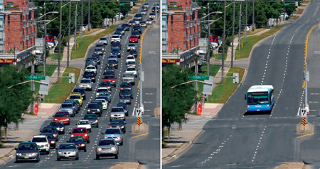
The vivaNext rapidways being built across York Region are good news for the environment.  More people taking transit means less pollution. One Viva vehicle can replace up to 70 cars on the road – that represents a huge reduction in carbon emissions. With fewer cars on the road, gridlock, fuel use and air pollution caused by idling cars are all reduced.

There is also a direct connection between how our communities are developed, and the impact we have on our environment. Sprawling communities mean that people tend to travel farther between work, home and play. The more spread out a community is, the harder it is to provide efficient public transit. So, people become increasingly dependent on cars, and the developments that get built are more likely to be car-oriented. The more that happens, the less convenient it is for people to take transit. Eventually, entire communities become dependent on cars, and are less likely to use transit, cycle or walk to get around. More cars mean more gridlock, more pollution and more carbon emissions.

On the other hand, communities that are developed around great transit are more likely to include compact, pedestrian-friendly neighbourhoods.  Mixed-use developments and shorter distances between work-live-play destinations make it easier to get around and make transit a more appealing and convenient choice for a greater number of people.

The result: more people out and about, enjoying their energetic and dynamic local neighbourhood, and walking in the fresh air to ride in a comfortable, low-emission Viva vehicle.

And for people who continue to drive, their trips will be shorter due to the compact, mixed-use developments that have sprung up around transit – so once again, car usage will be reduced, resulting in less pollution and fuel consumption.

All of this is good news for the environment, for our health, and for our lifestyle.

Categories
Community Events

Come out to the Woodbridge Italian Festival this weekend!

woodbridge_italian_festival_2010_07_26

The 22nd annual Woodbridge Italian Festival promises a weekend of fun for the entire family! It will feature live music, dancing, the Miss Woodbridge Italia pageant, a classic car show, sports demonstrations and much more. Be sure to catch local politicians battling it out on the soccer field against media personalities in the VIP Soccer Challenge. And if that’s not enough soccer for you, there are four other exciting soccer matches to watch!

The festival takes place at the Ontario Soccer Centre on Saturday, July 31 and Sunday, August 1. Admission is free. There will be both indoor and outdoor vendors and exhibitors, with delicious food, refreshments, merchandise, and services. The vivaNext team will be outdoors, so be sure to look for our blue tent!  Stop by to get the latest information on vivaNext projects and to receive a great giveaway.

Hope to see you there!

Woodbridge Italian Festival 2010

Where: Ontario Soccer Centre
7601 Martin Grove Road (just south of Highway 7), Woodbridge
When: July 31 & August 1, 2:30 – 11pm

Categories
Live-work-play Rapidways Urban Planning

How transit shapes development

blog_10_07_16_b

You’ve probably noticed that in several of my earlier posts, I have referred to the connection between transit and development. And you may have thought to yourself: “How can transit, which helps people get around, have anything to do with the kind of buildings that get built, and where they go?” Good question!

Historically, people have tended to settle and build at points along popular travel routes. And as places get built up, they attract more people, and more building. There is, and always has been, a linkage between the location of travel routes and the location of development. Here’s one interesting local example: archeologists working on the vivaNext project have focused their work on areas where creeks and the roadway intersect. Why? There is a greater chance of finding artifacts in such locations, because in the past, people travelling along those creeks would have stopped nearby for rest, for shelter, or to settle.

Another example in more recent Canadian history is that of the railways. When the railways were built across the country, little towns shortly began popping up all along the route. Many communities were built, or became as large as they did, because of the railways.

These examples demonstrate the strong relationship between transit and development. As a form of urban travel, transit creates natural stopping points along its routes. The more people there are using the transit system, the more activity there is at these points. Rapid transit–a form of transit that moves a high volume of people-creates stopping points with the potential to be visited by large numbers of people; this in turn spurs development.

Land use planners know this, which is why transit is a core component of York Region’s plan for managing future growth. Much of the new growth coming to York Region will take place in the areas closest to and along the transit routes. The transit routes have thus been planned in tandem with larger efforts to shape where growth will happen, tapping into the human pattern of wanting to build near travel routes.

We are already seeing proof that the pattern is once again playing out as expected, with many new developments being planned along the future vivaNext rapidways. Next time, I’ll talk more about the kind of development that you can expect to see along the rapidways.

Categories
Live-work-play Rapidways Urban Planning

Public transit = more housing choices

housingcollage_10_07_12-copy

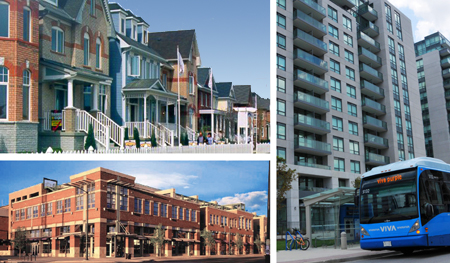
Here’s some new math you may not have seen before: vivaNext = more housing choices. How can that be? Let’s start by talking about housing options, and why they matter.

The expression, “one-size-fits-all,” applies to many things, but when it comes to housing preferences, we all have our own ideas about how we want to live. A traditional suburban house might be the perfect dream home for one person, but might be too big or too – well, suburban – for another. A stylish condo with a sleek balcony within walking-distance of entertainment and shopping is just what some people are looking for, but wouldn’t suit everyone.

No matter what our personal preferences might be, one of the values that most of us share is that we’d like to be able to choose where we live. Unfortunately, if a range of housing options is not available, it can be difficult for people to find suitable homes in a particular neighbourhood or community. And that’s a shame, because being able to stay in a neighbourhood you like, near friends and family, close to familiar services and supports – near your roots – means a lot to many people.

By bringing rapid transit to York Region, vivaNext will support the development of a wider range of housing options, so that every member of a family, whether they’re parents with young children, young adults moving out for the first time, or older people wanting to downsize, can live near the neighbourhood of their choice.

As a key component of the transit-oriented development being planned along the rapidways, new housing will be built, especially near the new centres that will be created in Markham, Newmarket, Richmond Hill and Vaughan. Almost all of the housing in these centres will be multi-unit, higher density apartments and condominiums. Elsewhere, other established neighbourhoods will be kept predominantly single family housing.

With so much of the new growth and housing planned in centres and along the rapidways, there will be less pressure on other areas to become more densely built up, allowing them to stay much the same. The ultimate goal is to preserve the balance around the region, offering more choice and more flexibility for people – no matter what stage of life they may be at, or their housing preferences.

Having more housing options means every member of your family can choose to stay in the community they love, even as their needs change over time. We’re pretty excited to think that vivaNext will help achieve such an important goal.

Categories
Announcements Stations Subways

View the final designs for two Spadina Subway stations!

spadina-stations-final-designs_2010_07_06

On Thursday, July 8, and Tuesday, July 13, 2010, you are invited to view the final designs of two stations along the Spadina Subway extension: Sheppard West Station and Highway 407 Station.

The Toronto-York Spadina Subway Extension project will extend 8.6 kilometres north from Toronto’s Downsview Station to the Vaughan Metropolitan Centre at Highway 7. The project will better connect people to their destinations of choice, and will help Vaughan fulfill its vision for future growth and development.

We encourage you to attend these two public open houses and share the excitement as rapid transit plans move forward in York Region.

Sheppard West Station Public Open House

Date: Thursday, July 8, 2010
Time: 4 – 7:30pm
Location: TTC Downsview Station – Bus Terminal Platform
At the intersection of Allen Road and Sheppard Avenue West
Access to Bus Terminal Platform through “Passenger Pick up and Drop off”

Highway 407 Station Public Open House

Date: Tuesday, July 13, 2010
Time: 6:30 – 8:30pm
Location: The Hilton Garden Inn – Toscana Centre
3201 Highway 7, Vaughan

Take Transit: From Downsview Station take Viva Orange 077/077A or Viva Orange 107 to arrive at the doorstep of the Hilton Garden Inn, at the intersection of Highway 7 and Edgeley/Interchange Way.