Categories
Subways Urban Planning

subway in the GTA: where & when to build

subway in the GTA: where & when to build

With the launch of the #YongeSubwayNow petition and campaign for full funding of the Yonge Subway Extension, there has been a lot of conversation around where subway should be built, and whether the Yonge Subway Extension or Downtown Relief Line should be built first.

At York Region Rapid Transit Corporation [vivaNext] we’ve been leading the design and engineering studies for the Yonge Subway Extension, so we have a few thoughts on these important topics.


considering the options

To some it might seem as if the Yonge Subway Extension is a new plan, but really it’s been in the works for many years, and it’s pretty far along. It was first included in York Region’s Official Plan over 20 years ago in 1994. The Environmental Assessment was completed and approved way back in 2009, and in 2012 the Conceptual Design Study was completed and approved by TTC and York Region.

This isn’t a blind push for a subway – we’ve looked carefully at the options. LRT and dedicated BRT lanes were considered, but due to factors such as narrow road space and high ridership, only a subway will work here.


building in parallel

Transit should not be a York vs. Toronto issue. Instead, the focus should be on what investments will contribute best to helping people get where they need to go conveniently and most cost-effectively. That’s why, for example, we think both the Yonge Subway Extension and the Downtown Relief Line need to be built. And we know the Province of Ontario agrees, because both projects are on Metrolinx’ list of top priority projects. In fact, a relief line that reaches all the way to Sheppard Subway would be particularly helpful to the Yonge Line, especially if a rapid transit connection can be added later to travel north from Sheppard.

Transit expansion benefits people on both sides of our municipal borders. Today, we see a significant number of travelers headed northbound in the AM period to a growing number of jobs in York Region. Cross-boundary transit reduces traffic congestion on GTA roads, and increases the pool of customers and skilled employees for Toronto businesses.

With the current state of transit in the GTA, transit projects that are as important as these shouldn’t be built consecutively. Projects like these typically take at least 10 years to design and build, so they should be built in parallel. We can’t wait for one to be complete before starting another.

A GTA transit network means expanding options and crossing borders. It means we have to move forward with as much transit as possible, in the places where it’s needed. And we can all benefit from that.


Categories
Live-work-play Urban Planning

going where the action is

going where the action is

In York Region, there are over 120 bus routes travelled by Viva and YRT buses, and some are busier than others. Some of the busiest routes are on Yonge, Highway 7, Bathurst and Centre Streets, Bayview Avenue and Leslie Street. If you live or work in York Region, there’s a good chance that you travel one of these roads regularly, so it’s no surprise that other people want to go there too.

When building transit, planners have a few goals in mind: ensure most people have access to transportation; have transit where people want to get on and off; and be prepared for future growth and development.

Ensuring most people have access to transportation allows people to get where they want to go, even if they have a specific need or live in a less populated area. In York Region, Dial-a-Ride, community buses and seasonal services [like Canada’s Wonderland!] are examples of this. Community buses take people to places where there’s a special interest, like hospitals, plazas and schools.

The most popular transit routes go where people want to get on and off. People want to go where the action is, so routes are planned where shopping, services, jobs, and higher-density housing is already along the way. One example of this is the area around Bathurst and Centre Streets, where shops and amenities are walking distance to a transit terminal and multi-story condo buildings. Connections to other transit are a big draw too – so routes are planned near bus terminals, GO stations, and future subway stations.

In some cases, we’re preparing for future growth by building transit before development. Enterprise Boulevard in Markham is a planned downtown area near the Unionville GO Train Station that only seven years ago was mostly vacant fields. We opened the first segment of rapidway there in 2011, and since then condo buildings, a sports facility, shops, restaurants and entertainment have all been built, and hotels and a York University campus are on the way.

Whether development is already there or on the way, transit planning means making sure transit is easy to access, and goes where people want to go – an important element in building great communities.


Categories
Urban Planning

building in place >> the best of both worlds

building in place >> the best of both worlds

Earlier this month, the Province of Ontario proposed changes to the four provincial plans that shape how land is used in the Greater Golden Horseshoe: Growth Plan for the Greater Golden Horseshoe, the Greenbelt Plan, the Oak Ridges Moraine Conservation Plan and the Niagara Escarpment Plan. They’re gathering feedback from the public on all their recommended changes to help protect green spaces and farmland.

One of the key changes proposed is an increase in the minimum Intensification Rate from 40% to 60%, to encourage growth in central areas and reduce suburban sprawl. “Intensification” may sound unfriendly but really it’s just re-using space that we already have. We’ve been building on land in York Region for many decades and our population continues to grow, so when a building comes to the end of its life, there’s a good chance the next building on that land will need to serve more people – whether for housing, business or entertainment.

For example, if a one-level plaza has 10 businesses, when it’s time to rebuild it might be replaced with a five-story building with 15 retail and restaurants on the ground level and 15 apartments above. Because there are more business and residential units than there were before, this contributes to an increased Intensification Rate in the area.

By building in place, adding five business units and 15 residential units to this property instead of building 10-20 detached subdivision houses elsewhere, an acre of green space could be saved. If this new development hosts 80 or more residents and jobs per hectare [2.5 acres], then it also helps support frequent transit service [like a Viva rapidway!].

One proposed change from the Province is to require zoning along transit corridors that supports a higher population and walkable communities. This is important to keep the relationship between people and transit on track. Transit systems need lots of people to jump on board, and people living in downtown areas need the option of transit.

By continuing to build in place, our biggest towns and cities will have everything on their doorstep, and green space nearby. Doesn’t that sound like the best of both worlds?


Categories
Rapidways Urban Planning

New book on ‘complete streets’ highlights the Highway 7 East vivaNext project

New book on ‘complete streets’ highlights the Highway 7 East vivaNext project

The Toronto Centre for Active Transportation [TCAT] has recently published a book on street-transformation projects, called: Complete Street Transformations in the Greater Golden Horseshoe. One of the projects they featured is the vivaNext rapidway on Highway 7 East in Markham and Richmond Hill!

The book includes nine different street-transformation projects from southern Ontario that, according to TCAT, “involved redesigning streets to make more space for one or more of pedestrians, cyclists, or transit riders.”

They also present outputs and outcomes of each project. For the Highway 7 East project, they comment on the safety improvement brought by the transformation, the increase in pedestrians and have included a cyclist and pedestrian count in one segment of the street. And, of course, they also note the improvement in transit travel times, with the BRT shortening the average transit rider’s commute by over 30%.

The most recent edition of Novae Res Urbis (GTA), the urban planning magazine, promoted Complete Street Transformations and said this about the vivaNext project:

“By far the most ambitious project highlighted in the book was the $308-million transformation of Highway 7 East in the City of Markham and Town of Richmond Hill. The former provincial highway was transformed into a multi-modal transportation corridor with bicycle lanes and a dedicated transitway. The result was a dramatic increase in the number of pedestrians, cyclists and transit users in the corridor, as well as a 64 per cent reduction in collisions.”

You can download a copy of the book here. The good stuff about the Highway 7 East project starts on Page 11!

Questions or comments? Comment below or email us at contactus@vivanext.com. To stay up-to-date on construction, sign up for email updates at vivanext.com/subscribe.


Categories
General Urban Planning

automated vehicles >> will transit drive itself?

automated vehicles >> will transit drive itself?

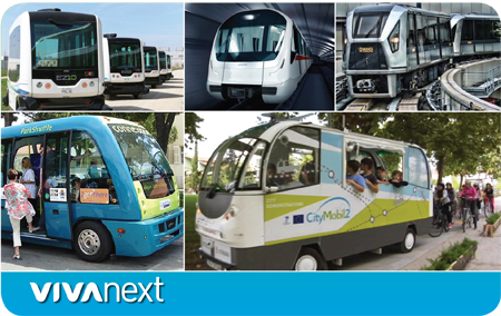
Lately there’s been a lot of news on the topic of automated vehicles. In February, the National Highway Traffic Safety Administration in the US officially stated that an artificial intelligence system [computer] in an automated vehicle can officially be considered a driver. And in at least five global cities, there are driverless buses already on the streets. In aviation, pilots have been relying on auto-pilot for decades when landing and taking off in low visibility, and many people-mover rail systems [such as airport monorails] are automated.

Studies show that, statistically speaking, computers are safer than humans at driving. However, we know that getting from here to there is about more than arriving safely. Comfort is important of course, along with convenience and efficiency or speed. For some, a travel choice is a personal statement – to cycle or walk, to make use of transit, or to drive a certain style of car. Many vehicles already have “driver assistance systems,” with features that brake when an obstacle is detected, and alert the driver when the car in front has moved forward or when the vehicle has left its traffic lane.

So the technology is there, and it’s already being used. The question isn’t whether it will happen, it’s how it will affect how we travel. It will depend on how they’re used – if every individual uses their own automated vehicle, traffic congestion and parking issues will likely remain the same. But if we share vehicles and take transit…our cities and roads could become safer and more efficient.  Interesting topics for discussion and consideration and we continue to follow them with interest.

At vivaNext we’re for mobility – whether this means subway, bus rapid transit, or automated transit in the future, we’re thinking about how York Region’s roads can be prepared and always looking for new and innovative ideas to make improvements.


Categories
Rapidways Urban Planning

building complete streets in York Region

building complete streets in York Region

When looking at the award winning rapidway on Highway 7 in Richmond Hill and Markham, or Davis Drive in Newmarket, you’ll notice some features that make them different from your average street.

Wider sidewalks, more accessibility features, large attractive tree planters to provide a buffer between pedestrians and traffic, and bike lanes where possible, are all part of York Region’s urban design philosophy. It’s an approach that will shape the future of our communities and neighbourhoods, and it’s what Urban Planners call a ‘complete street’ – a street designed for everyone.

The complete street transformation is starting to unfold on Yonge Street in Richmond Hill and Newmarket this year. Utilities are being relocated to accommodate the dedicated bus rapid transit lanes in the centre of the road. In time, the same thoughtful and elegant elements will take shape on one of the region’s most important roads for transportation, commerce and entertainment – the perfect place to stop, shop and dine – Yonge Street!

The complete street approach ensures that planners and engineers design and manage public infrastructure that takes in account users of all ages, abilities, and modes of travel.

One of the underpinnings of the complete street approach is to treat roads as destinations. With careful planning, roads can be public spaces with lush greenery and design features that engage people. Streets can be places to go instead of just surfaces to drive on. They should connect to businesses and places where people live, and also to trails, parks and other gathering places in order to help build a sense of community.

Another key consideration is accessibility, because whether you get around in a stroller, wheelchair, on transit, walking, cycling or driving, everyone needs safe and convenient options.

To learn more about complete streets and how they are being implemented across Canada and around the world, visit completestreetsforcanada.ca, or smartgrowthamerica.org.


Categories
Going Green Urban Planning

farms need cities

farms need cities

Most people would agree that outside the city limits, there should be rural, green space. It’s important for agriculture, for wildlife, and for us to experience our natural landscape.

The Oak Ridges Moraine Act [2001] and the Greenbelt Act [2005] together protect 69% of York Region’s land. Considering York Region’s fast growth, the remaining 31% needs to be carefully planned, with higher density in the cities.

Farmland has changed in Ontario over the last several decades, with fewer, larger farms and more technology used for efficient production. Wildlife has changed too, with York Regional Forests in place and more awareness of our impact on nature. But one thing that hasn’t, and likely won’t, change is that wildlife and farms need cities to grow in place, without expanding into the countryside.

This is where new urbanism and transit-oriented development come in. They’re about planning the best ways for a city to grow, and ensuring there’s a variety of housing and employment, and transportation options like bus rapid transit and subway. Building where we already have development makes a lot of sense. It keeps urban, urban and protects rural from becoming suburban. It also creates a focused city centre that attracts people to do business or shop, all of which is supported by great transit to get around.

Using the land we already have in York Region’s cities and towns is smart and it’s sustainable. If we stick to this plan we’ll be watching population grow in our vibrant cities, and trees and crops thrive in the country.


Categories
Construction Urban Planning

Yonge Street >> the route to change

Yonge Street >> the route to change

Yonge Street has a long and storied past as a hub for shopping, entertainment and culture along its full length. There are many examples of change and transition as you follow its route from the shores of Lake Ontario all the way north to York Region.

You’ll start to see another transformation this year in Richmond Hill and Newmarket as we begin work on a rapidway – dedicated lanes for Viva – along key segments of Yonge Street.

But how did we arrive at this plan? How does it fit in with the existing network?

There are many layers of planning that have helped develop our approach to meeting the transit needs of York Region and ensuring we’re ready for the increasing demand that comes with population growth.

It all stems from The Big Move, a plan by Metrolinx [a provincial agency] that outlines a vision for a connected transportation network in the Greater Toronto and Hamilton Area [GTHA], one of the largest and fastest-growing urban regions in North America.

Following Metrolinx’s plans, York Region’s Transportation Master Plan lays out the blueprint for addressing transportation and mobility needs of those living and working in York Region over the next 25 years. It plans for region-wide infrastructure that is welcoming to everyone, including drivers, transit customers, cyclists and pedestrians.

Out of that blueprint comes York Region’s Centres and Corridors Program. This plan identifies the key urban centres and corridors in York Region where new growth and development will be focused. These key urban centres are located in Richmond Hill, Vaughan, Markham, and Newmarket – and each of these municipalities have a need for managed growth and a connected transportation network for the future.

That’s where vivaNext comes in. We’re where the rubber hits the road, connecting urban centres along key corridors with fast, efficient rapid transit. We’ve done all the ground work, completing the comprehensive environmental assessments, reaching out to the community for input on the design, coordinating with the utility companies to adjust their infrastructure, and awarding the contract to get the job done.

We’ve already opened 8.6 km of rapidways on Highway 7 and Davis Drive, and we’re looking forward to the future transformation of Yonge Street.

To learn more about the Yonge Street rapidway and the construction activities ahead, visit our project page and subscribe for email updates.


Categories
Urban Planning

from suburban to urban

suburban to urban

York Region’s urban centres are becoming vibrant locations for residents and visitors, growing with new urban cultural attractions – thanks to the support of a rapid transit system.

Exciting growth and new developments featuring modern architecture are popping up in the areas where rapidways are being built, including Vaughan, Markham, Richmond Hill, and Newmarket. Much of these developments are compact and mixed-use, providing new places to live and work right on peoples’ doorsteps. And the best part is that all these attractions will be conveniently located next to fast, reliable transit – making it easier than ever for people to connect within the Region. When amenities are close by and getting around is easy, a community truly feels connected.

As York Region grows, vivaNext is growing right along with it. Adding a rapid transit system with sleek, modern stations and pedestrian and cyclist-friendly streetscapes, contributes to the feeling of being in the centre of things. It also promotes alternative modes of transportation, helping shift residents away from the car-dependent culture toward a more urban, transit-supportive way of living. It’s wonderful to have transportation choices right on your doorstep. York Region is transforming and the future looks bright! Pictures paint a great picture – check out our video to see the changes unfolding.


Categories
economic & financial Urban Planning

strong foundations

click to see the video: strong foundations

If you’ve seen the completed rapidway on Highway 7 East, you’ll know that the roadway has gotten a major facelift. VivaNext is building sleek, modern and welcoming transit stations and streetscapes throughout York Region. But that’s not all. During the construction of each new rapidway, older infrastructure is upgraded to lay a strong foundation for the social and economic development that will accompany a rapid transit network.

York Region’s population is expected to increase by 600,000 by the year 2041. As York Region grows into a more urban destination, it’s important to ensure that we have the infrastructure necessary to support a larger, denser population. Taking the time to replace infrastructure during rapidway construction allows us to support this growth, while also reducing future maintenance and repair costs. As the rapidways are being built, water mains, storm sewers, street lights, and other utilities are also being upgraded, expanded or renewed, and bridges and culverts are being assessed and rebuilt as needed.

The future is promising and by investing in new infrastructure, vivaNext is supporting the prosperity of York Region’s communities well into the future. To see how we’re laying a strong foundation for social and economic growth, watch our video.