Categories
Rapidways Stations Urban Planning

Designing a rapidway

Designing a rapidway

Earlier this year, I wrote a series of blogs about planning for growth, discussing York Region’s long envisioned goal of a true rapid transit system. The system would have to connect regional centres and move the expanding population around quickly, without increasing car traffic. The plans for this rapid transit system have been in the works for several years, and given our population, we know that bus rapid transit (BRT) offers the right technology at this time.

But how did we get from knowing we wanted to have a BRT system, to the actual design of the rapidways?

The first design considerations went back to our basic goals for a rapid transit system: to move a lot of people around efficiently, and to not add to gridlock on the roads (in fact, to reduce gridlock). The easiest and fastest way to create rapidways on existing roads would have been to convert the curb lanes, replacing two lanes of traffic. While this option would have met our first goal of moving people around quickly, it would have also decreased existing road capacity – which would defeat our second goal of not adding to gridlock. This meant that we would have to add lanes to include the rapidways.

Once we knew that, the next design consideration was where to put those new rapidway lanes. Again, we referred back to our first goal: to move a lot of people around quickly. The basic benefit of rapid transit is that it provides a consistent, reliable way of getting from point A to point B. Riders know how often the vehicle will arrive, how long the trip will take, and they know they can count on it, no matter how heavy the traffic. So what are the design considerations to ensure a consistent, reliable ride?

One key design requirement is to provide level boarding, meaning that passengers don’t have to climb up or down steps onto the vehicle; for example, subways have level boarding. With level (or close to level) boarding, people have better access, regardless of their level of mobility or whether they are pushing a baby carriage. Level boarding allows more people to get on and off quickly and results in shorter dwell time, which means vehicles spend less time at stations. In short – level boarding helps make the service faster, which in turn helps vehicles keep to a schedule, and provide a consistently reliable, frequent service. These improvements make transit more appealing to more people – which meets our first goal.

But to provide level boarding, the platforms have to be close to bus floor height – which is about a foot off the ground (most sidewalks are closer to 6″ high). To provide higher platforms, our stations needed to be separated from sidewalks. Theoretically, we could have built higher platforms on the edges of sidewalks, but there are reasons why this isn’t ideal: our stations would take up too much of the sidewalk, which could interfere with local businesses. Therefore, the best place for our stations would be to have them physically separated from the sidewalk. In our case, this meant locating stations in the middle of the road. The benefit of having the stations in the median, is that passengers won’t have to walk all the way across the road to get to a station – they can meet us half-way.

But by adding the rapidways down the middle of the road, we then needed to widen the roads to accommodate both the rapidways as well as the existing traffic lanes. All of which takes us to our final design, which is have our rapidways running along the median, with median stations, and special left turn and u-turn lanes at intersections to allow drivers to safely and easily turn across the rapidways.

Of course, going this route has required more steps, including acquiring the land needed to widen the roads. But the end result is going to be a rapid transit system that meets our goals of providing fast, consistent transit, without adding to existing traffic congestion. And that’s a design solution that we can all be really proud of.

Categories
Rapidways Urban Planning

Planning for urban renewal on Davis Drive

Planning for Urban Renewal on Davis Drive

If you’ve driven along Newmarket’s Davis Drive recently, you’ve probably noticed the signs of impending construction work, including building demolitions and soil testing. These preliminary tasks are taking place to prepare the roadway before rapidway construction begins. The actual construction stage is the final step in what will have been a long process of planning for urban renewal and redesign along Davis Drive – a process that will transform this important street in some exciting ways.

Much of the planning for the Davis Drive rapidway is as concerned with urban design as it is with public transit improvements. So what do we mean by urban design and what are the issues on Davis Drive?

In general, urban design is about deliberately shaping neighbourhoods and cities using architecture, landscaping and city planning. It’s about arranging things such as buildings, public spaces, services and amenities, in a way that will provide a certain feel or character.

When we started to design the Davis Drive rapidway, we had a number of urban design objectives. It goes without saying that the rapidway needed to be both functional and attractive. As with all of the rapidways, Davis Drive will use a design sensibility that reminds people of how innovative, exciting and fun Viva is.  Every element we will be using along Davis Drive, from station features to the pavement, retaining walls, handrails, and lighting, will reflect and repeat a consistent, appealing look that speaks to what Viva is all about.

But more than that, in keeping with the principles of transit-oriented-development, we wanted to create new destinations along Davis Drive, making it even more welcoming and friendly for people. The idea is to make Davis Drive feel like an urban space, encouraging people to walk around and visit local shops and restaurants. And with increased visitors, new development is more likely to take place, resulting in even more destinations and potential visitors.

Our plans for Davis Drive include wider boulevards, with pleasantly planted areas, trees, street furniture and landscaping. High-quality pedestrian and street lighting will provide an attractive, welcoming environment at all times of day. These elements will be designed to a human scale, which will make people feel more comfortable walking around and enjoying the sights and activities.

Another design objective has been to forge a strong connection between the heritage flavour of Main Street and Davis Drive itself. Main Street has a lot of character, and we want to extend some of that charm out onto Davis Drive; we want to provide a cue to people as they travel along Davis Drive that they are entering the old-time heart of Newmarket. So around the intersection of Main and Davis, our rapidway design will include some elements to visually connect the rapidways to the heritage area, including the street furniture, lighting design and the bridge over the East Holland River. We hope that people will be intrigued by the change in visual tone, and will want to explore more of the heritage shopping areas along Main Street.

Of course, with construction ahead of us, the final product is a ways off. Even so, we’re really excited about the urban renewal that we are a part of on Davis Drive, and we can’t wait to get underway!

Categories
Live-work-play Rapidways Urban Planning

Why “TOD” is great news for all of us

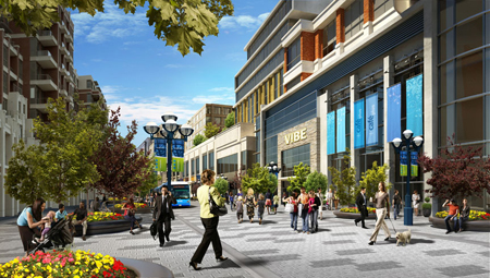
A rendering of transit-oriented development in Markham
A rendering of transit-oriented development at the future Markham Centre

Recently, I wrote about transit and the role it has in shaping communities, in particular, the development that tends to spring up along transit routes and around stations. This time, I want to talk more about what we mean by “transit-oriented-development” ( TOD for short), and why this kind of development will be good news for people in York Region—whether or not they are transit users themselves.

Most people get around York Region by car – possibly because they want to – but also because some people find it challenging to do all the things they need to do in a day by transit. That’s not surprising in a region like this one; in communities where development has been shaped by a long-standing car culture, destinations are more likely to be spread out, with greater distances between live-work-play destinations. Even the design of buildings may be shaped by car usage, with large parking lots separating buildings from roads.

The idea behind TOD is that people using transit are also likely to be pedestrians at some point during their journey – either at the beginning, or the end (or both). Studies have shown that people are willing to walk about 5 minutes to or from transit, which is somewhere between 400 and 600 metres. So TOD uses the approach of creating a complete community within walking distance of transit – including workplaces, homes, shopping, recreation and services. The thinking is that if new developments are designed to be conveniently compact and appealing to pedestrians, people are more likely to leave their car at home for at least one of their trips. Obviously, the good news is that more people taking transit means fewer cars on the road, less pollution, and less gridlock.

So York Region planners have linked the plans for the vivaNext rapidways to land use policies that will result in more TOD along Viva routes and near vivastations. These policies will likely mean that much of the new development built around vivastations will be compact and mixed-use, providing housing, employment, retail, dining, services and recreation, all within a walkable distance of transit. Developments will also include more welcoming public spaces, attractive landscaping, and other amenities so that people enjoy being out and about.

How will this affect you? In a pre-TOD scenario, a typical day could start with a drive to work, then a drive to a restaurant for dinner, ending with a drive to a movie or concert before driving back home. With more TOD, you would have the choice of taking transit to work, then walking around the corner from the office to dinner, then strolling across the street for a show before grabbing a coffee and getting home again by transit. Same day, two different ways of getting around.

The point is that transit and TOD don’t have to change the way people live in York Region, but it will give us all more choices – in what we do, where we do it, and how we get there. We think that’s good news for everyone.

Categories
Going Green Rapidways Urban Planning

Colouring Viva blue – and green

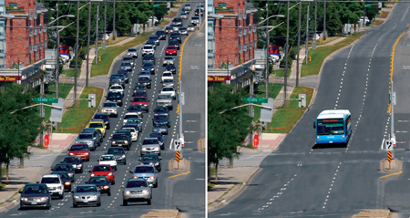
70-cars-before-and-after

The vivaNext rapidways being built across York Region are good news for the environment.  More people taking transit means less pollution. One Viva vehicle can replace up to 70 cars on the road – that represents a huge reduction in carbon emissions. With fewer cars on the road, gridlock, fuel use and air pollution caused by idling cars are all reduced.

There is also a direct connection between how our communities are developed, and the impact we have on our environment. Sprawling communities mean that people tend to travel farther between work, home and play. The more spread out a community is, the harder it is to provide efficient public transit. So, people become increasingly dependent on cars, and the developments that get built are more likely to be car-oriented. The more that happens, the less convenient it is for people to take transit. Eventually, entire communities become dependent on cars, and are less likely to use transit, cycle or walk to get around. More cars mean more gridlock, more pollution and more carbon emissions.

On the other hand, communities that are developed around great transit are more likely to include compact, pedestrian-friendly neighbourhoods.  Mixed-use developments and shorter distances between work-live-play destinations make it easier to get around and make transit a more appealing and convenient choice for a greater number of people.

The result: more people out and about, enjoying their energetic and dynamic local neighbourhood, and walking in the fresh air to ride in a comfortable, low-emission Viva vehicle.

And for people who continue to drive, their trips will be shorter due to the compact, mixed-use developments that have sprung up around transit – so once again, car usage will be reduced, resulting in less pollution and fuel consumption.

All of this is good news for the environment, for our health, and for our lifestyle.

Categories
Live-work-play Rapidways Urban Planning

How transit shapes development

blog_10_07_16_b

You’ve probably noticed that in several of my earlier posts, I have referred to the connection between transit and development. And you may have thought to yourself: “How can transit, which helps people get around, have anything to do with the kind of buildings that get built, and where they go?” Good question!

Historically, people have tended to settle and build at points along popular travel routes. And as places get built up, they attract more people, and more building. There is, and always has been, a linkage between the location of travel routes and the location of development. Here’s one interesting local example: archeologists working on the vivaNext project have focused their work on areas where creeks and the roadway intersect. Why? There is a greater chance of finding artifacts in such locations, because in the past, people travelling along those creeks would have stopped nearby for rest, for shelter, or to settle.

Another example in more recent Canadian history is that of the railways. When the railways were built across the country, little towns shortly began popping up all along the route. Many communities were built, or became as large as they did, because of the railways.

These examples demonstrate the strong relationship between transit and development. As a form of urban travel, transit creates natural stopping points along its routes. The more people there are using the transit system, the more activity there is at these points. Rapid transit–a form of transit that moves a high volume of people-creates stopping points with the potential to be visited by large numbers of people; this in turn spurs development.

Land use planners know this, which is why transit is a core component of York Region’s plan for managing future growth. Much of the new growth coming to York Region will take place in the areas closest to and along the transit routes. The transit routes have thus been planned in tandem with larger efforts to shape where growth will happen, tapping into the human pattern of wanting to build near travel routes.

We are already seeing proof that the pattern is once again playing out as expected, with many new developments being planned along the future vivaNext rapidways. Next time, I’ll talk more about the kind of development that you can expect to see along the rapidways.

Categories
Live-work-play Rapidways Urban Planning

Public transit = more housing choices

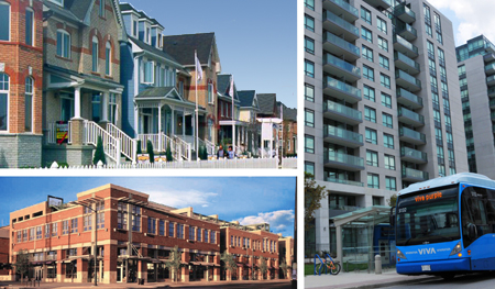
housingcollage_10_07_12-copy

Here’s some new math you may not have seen before: vivaNext = more housing choices. How can that be? Let’s start by talking about housing options, and why they matter.

The expression, “one-size-fits-all,” applies to many things, but when it comes to housing preferences, we all have our own ideas about how we want to live. A traditional suburban house might be the perfect dream home for one person, but might be too big or too – well, suburban – for another. A stylish condo with a sleek balcony within walking-distance of entertainment and shopping is just what some people are looking for, but wouldn’t suit everyone.

No matter what our personal preferences might be, one of the values that most of us share is that we’d like to be able to choose where we live. Unfortunately, if a range of housing options is not available, it can be difficult for people to find suitable homes in a particular neighbourhood or community. And that’s a shame, because being able to stay in a neighbourhood you like, near friends and family, close to familiar services and supports – near your roots – means a lot to many people.

By bringing rapid transit to York Region, vivaNext will support the development of a wider range of housing options, so that every member of a family, whether they’re parents with young children, young adults moving out for the first time, or older people wanting to downsize, can live near the neighbourhood of their choice.

As a key component of the transit-oriented development being planned along the rapidways, new housing will be built, especially near the new centres that will be created in Markham, Newmarket, Richmond Hill and Vaughan. Almost all of the housing in these centres will be multi-unit, higher density apartments and condominiums. Elsewhere, other established neighbourhoods will be kept predominantly single family housing.

With so much of the new growth and housing planned in centres and along the rapidways, there will be less pressure on other areas to become more densely built up, allowing them to stay much the same. The ultimate goal is to preserve the balance around the region, offering more choice and more flexibility for people – no matter what stage of life they may be at, or their housing preferences.

Having more housing options means every member of your family can choose to stay in the community they love, even as their needs change over time. We’re pretty excited to think that vivaNext will help achieve such an important goal.

Categories
Live-work-play Urban Planning

Seeing into the future with York Region’s Official Plan

futurebuilds

What’s the best way to see what the future will look like for York Region? A crystal ball? Cards? Tea-leaves?

In all seriousness, when it comes to reading the future for our community, I suggest you look at York Region’s Official Plan. This document, which is a critical planning tool, has a number of functions: it’s a public document used to describe and promote our vision for the future, but it is also a legal document used to support and defend key decisions related to public infrastructure, development and growth.

Based on a 25 year planning timeframe but updated every five years, York Region’s Official Plan sets out several key themes which will guide planning decisions, and will help make growth work for us.

One of the main themes throughout the plan is the desire to concentrate growth and development in key areas through the region. This will be done through the further development of a series of centres and corridors, meaning new downtowns in Markham, Newmarket, Richmond Hill and Vaughan. The idea is that by building more intensively in these areas, there will be less pressure for growth in the existing communities.

These new multi-use centres will be connected by transportation “corridors” that will make it easier for people to get around the region. And obviously, the best way to travel will be on the vivaNext rapidways, which will run along the corridors and connect the centres.

As they develop, the centres will become focal points for exciting new destinations, offering more choices in entertainment, dining, shopping, and other kinds of attractions. They will also provide higher density housing in condominiums and apartments, for people who like the idea of living at the centre of the action. These new downtowns will be designed with people in mind: they will include attractive, public open spaces where people feel welcomed, and be designed in ways that encourage walking, cycling and transit use.

The Official Plan recognizes that while many people may like the idea of heading to one of the newly urbanized centres to dine out, to shop, or to go to work, they may also want to have a home in a quiet residential neighbourhood. So the Official Plan directs that those kinds of communities will be protected from the kind of intensification that will be used in the centres, so people can continue to enjoy the lifestyles they already have.

And because people in York Region value the greenspaces that make up such an important part of this area, a full 69% of the Region’s landmass will be protected as either Greenbelt or Oak Ridges Moraine.

The Official Plan goes into a lot of detail on these main themes, as well as a range of others, and is well worth reading to give you a sense of how your Region is going to manage growth into the future, and how it is going to evolve.

I like to think that with this well-thought-out plan, people in York Region will truly be able to have it all: our familiar communities will be protected, but we’ll get the benefits of city-building; and we’ll have a great rapid transit system to move us easily between all sorts of exciting new destinations. We’d love to hear your thoughts on this future vision, and what it will mean for you and your family!

Categories
Live-work-play Urban Planning

Shaping the vision for the future

official-plan_2010_06_071

When you think of York Region, what comes to mind for you? The comfortable, tree-lined family-friendly neighbourhoods of Aurora or Vaughan? Or maybe the increasingly urban appearance of Markham’s new development areas, with many large head offices employing thousands of professionals? Or maybe the quaint, walking-scale downtowns of Newmarket, Unionville or old Richmond Hill? Not to mention the lovely green countryside that wraps all around our towns, offering recreation, productive farmland, and rural lifestyles. Maybe you think of how some downtown sidewalk areas could be more inviting, how much longer it’s taking you to get to work these days, or how it’s hard to get from A to B in York Region if you don’t have a car.

It’s probably safe to say that everyone in York Region has a view of what their home community means to them, and what they’d like it to be in the future. If asked, most of us could list the things we love, and the things we’d love more of (or in the case of some things, like traffic gridlock, less of!)

So when it came time to update York Region’s Official Plan, residents were asked to describe their vision for the York Region of the future. The input for the Official Plan makes a great snapshot of what people want out of their home in York Region, and what matters to them, which include:

  • Let’s be green;
  • Let’s try to live and work in the same community;
  • Let’s make it more beautiful;
  • Let’s make it lively, with lots of interesting things to do;
  • Let’s live in neighbourhoods that are designed to let us get to know our neighbours;
  • Let’s have more choices in housing availability, to accommodate every member of our community – families, single people, young and old;
  • And to tie it all together – let’s make it easier to get around, with or without a car.

That’s what people said, and then planners had to figure out how to make that vision come to life, looking twenty and even thirty or more years into the future. That vision is captured in a hefty document that is York Region’s Official Plan.

So what’s all this got to do with vivaNext? I’m going to tell you more over the next couple of blog posts, but here’s a hint: one of the key things that’s going to help achieve that vision of a greener, livelier, more compact York Region, is a rapid transit network. More than just transit, the vivaNext plan will help to shape our community into the future, and help bring those things people want – more choice, more opportunity, more green, more fun– to life. So whether or not you take transit, having vivaNext is very good news, and will be great for our community.

Categories
Live-work-play Urban Planning

Sand castles and city building

sandcastles-and-city-buildng_2010_04_29lRemember when you were a kid in a sandbox, and you could have endless fun with sticks and pebbles, building imaginary cities and towns, with houses, stores, roads and schools. You would make sure your city had everything people would want (including great rapid transit to zip people from the drawbridge to the castle), everything would be perfectly organized, and nothing would be too far away.
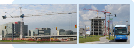
Believe it or not, there’s a grown-up version of that same activity, with the not-so-catchy title of Land Use Planning. Although you may never have heard this term, land use planning affects every aspect of life in your community today, and how you will be living your life in the future. And one of the most direct ways land use planning affects you, is through your municipality’s official plan.

Every municipality in Ontario must – by law – have an official plan, which has to correspond to plans already established by more senior levels of government. For example, York Region’s Official Plan has to fit within the overall Growth Plan for the Greater Golden Horseshoe, and York Region’s municipalities’ plans need to fit within the overall Regional plan.

Official plans are updated every few years, based on much discussion and public consultation. Just like the sand-box version, official plans identify which parts of town will be where people will work, which ones will be for housing, and which might accommodate both. Working with provincial rules, such as those set out in the Greenbelt Act and Places to Grow, official plans identify which parts of town will grow and which ones will be protected from growth. They identify the main roads, how much traffic those roads can carry before gridlock brings them to a stop, and where transit services will be needed to move people around.

(Hint – York Region’s current Official Plan, which I want to talk about more in my next blog, calls for a heavy expansion of rapid transit across the Region to help us cope with growth – which is why implementing our vivaNext plan is such a high priority for York Region).

Official plans also reflect the values and priorities shared by the community, such as a concern for the environment, or the need for a range of housing choices. An official plan reflects and shapes its community, and provides a road-map for how the community is going to grow – and respond to growth – into the future.

Of course, planning a real-life community is a huge responsibility that can affect the day-to-day lives of thousands or even millions of people. So getting it right is important, and takes a long time and a great deal of care; after all, unlike the sand version, redoing an official plan takes more than a sweep of a shovel. Hearing from the public is a critical part of developing an official plan – York Region’s current plan has a whopping 1,500 page appendix of submissions from the public!

So next time, let’s look at York Region’s December 2009 Official Plan, which highlights the importance of increased rapid transit for the York Region of the future. In the meantime, I’d love to hear from you: if you could go back to the sandbox, what would be in your perfect sand-city?

Links –
Ontario Ministry of Municipal Affairs and Housing Citizens’ Guides to Land-use Planning

Ontario Professional Planners Institute

Categories
Live-work-play Urban Planning

Making room for everyone

making-room_2010_04_19

There might have been a time when, as it grew, a community could just continue to expand its boundaries farther out into the surrounding countryside, adding new neighbourhoods as more people moved in. But in our increasingly crowded part of the province, we’re long past the time when municipalities can just spread out endlessly – our boundaries are pretty much fixed. So finding room for new people has to happen within our existing space.

With provincial legislation setting out formal growth targets for all Ontario communities, York Region has had to do some careful planning to map out where all those new people are going to live. And we’re not talking small increases – our planners have projected that by 2031, York Region will need to find room for an additional 577,000 residents and 234,000 households. And those new people need places to work, so planners also need to factor in room for an additional 180 million square feet of employment floor space, to accommodate the 318,000 new jobs that will be needed.

York Region is pretty big, so maybe those people can all spread out? No, it’s not that easy. In the first place, although some people prefer to live in more rural settings, the majority of people in York Region want to live close to amenities – near schools, near stores, near entertainment – near all the great things that make city life interesting and convenient. And those things tend to be clustered at the heart of our existing larger communities, like Markham, Newmarket, Richmond Hill and Vaughan.

Secondly, although York Region is quite large geographically, a lot of our lands are actually very fragile environments, and are protected against significant development. In fact, nearly 70% of our total land is protected under either the Green Belt Act, or the Oak Ridges Moraine Act.

To make this a win-win for everyone, the Region has adopted a planning strategy that directs almost half of the expected new growth to existing built-up areas, with the other half going to new development areas. This approach will result in more opportunities for people to live, work and play in the neighbourhoods that they already know and love, while reducing some of the growth pressure on the surrounding countryside.

The Region’s Centres and Corridors – which include the cores of Markham, Newmarket, Richmond Hill and Vaughan – will play an important role in this growth strategy. Most of the growth that will occur within the Region’s existing urban area will take place in the Centres and Corridors. With this concentration of growth, people will find it easier to get around using existing and planned rapid transit services, and to enjoy the exciting mix of living, employment, shopping and entertainment options that are already there, and that will continue to evolve.

Those of us working on vivaNext are excited about this plan, because it will put transit at the centre of the action as York Region grows into the future. I’d love to hear what you think of this vision, and what it will mean for how you live your life in York Region?