Categories
General Rapidways Stations Uncategorized

New vehicle + new rapidway + new station = Training

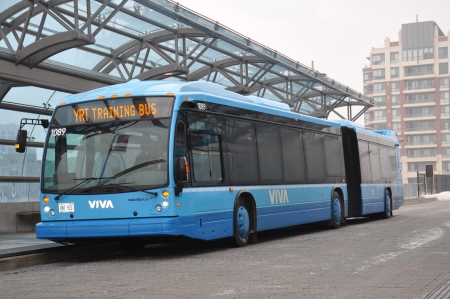
New Nova bus being used for training at Warden Station in Markham

It wasn’t that long ago that vivaNext was listing required specs for new Viva vehicles and testing design ideas for a rapid transit station. It feels like just yesterday that we were deciding station platform widths, highlighting accessibility requirements both on and off Viva and modelling the streetscape of the rapidways.

Now, some of the new vehicles have already arrived, the first new rapid transit station has been built in York Region and the first stretch of rapidway has been completed.

The new vehicles (made by Nova Bus) have great features – larger windows, a wider centre aisle, great lighting, and an accessibility ramp at the front door instead of at the middle. They’re powered by advanced clean diesel propulsion systems that produce fewer emissions, and we’re proud to say they’re manufactured in Canada. For drivers though, it also has new, unfamiliar on-board systems and controls.

The new vivastation is completely different from a typical transit shelter. It’s a rapid transit station, complete with heated waiting area, messaging boards and safety and accessibility features. It will serve our community for generations to come. However, with the platform being much higher than a street curb, Viva drivers must practise pulling into the station and review procedures related to its operations.

The rapidways allow Viva vehicles to bypass congested traffic as they operate in their own lane. Something drivers are also becoming more familiar with, now that the first stretch of rapidway is completed at Warden Ave. and Enterprise Blvd. in Markham.

Yes, training is a key focal point right now to ensure opening day goes without any unexpected inconvenience to our customers. Driver training on all of these elements has been underway for a while, and the Nova Buses are gradually being introduced into service. In just a matter of days now, we’ll see customers using the new Warden Station, boarding a new Viva vehicle and travelling down the new rapidway.

If you’re in the Warden Avenue and Enterprise Boulevard area, join us on opening day and bring your camera! Stay tuned for the official announcement and we’ll see you on the new platform on opening day with something special.

We love to hear from you, so if you’ve seen a Nova Bus or the new Warden Station, tell us what you think by replying to this blog, or by posting a comment on Facebook or Twitter. If you have a photo of yourself or your friends on the Nova Bus, we’d love to see those too!

Categories
General Uncategorized Urban Planning

A Transit-Oriented World

Transmetro Bus Rapid Transit system in Guatemala City, Guatemala

There are many cities where the fastest, most convenient way of getting around is by transit. Cities are planned and built over time, so no two cities are the same, and each one is planned based on identified needs or goals. A transit system built to meet an existing need may be effective in the short-term, but once a community is already built it can be complicated and costly to keep up with population growth by adding new transit infrastructure. To meet the long-term goal of an attractive destination to live, work, and play, transit systems need to be built beforehand to shape future development.

If they’re planned well, transit systems can be built with the ability to expand along with demand – for example from Bus Rapid Transit to Light Rail Transit. Building a transit system that will shape the community is the mindset, and the term we use for this is Transit-Oriented Development, or TOD.

TOD is a relatively new term but in one form or another, cities have been planned around transit for centuries. In historic Europe, roads, bridges and rail lines were built for wars, religious pilgrimages, and shipping goods, and where these roads met, communities grew. In Toronto, streetcar suburbs were created in the early 1900s as streetcar lines extended to new city limits with annexation to the north, west and east.

Currently, TOD is springing up all around the world on different landscapes and in different climates – Brisbane, Guatemala City, Hong Kong, and London to name a few. In North America, cities such as Vancouver, San Francisco and Arlington have a strong history of planning communities around transit, paving the way for similar developments in Edmonton, Calgary, Vancouver and Montreal. Closer to home, TOD is taking root in several communities such as Vaughan, Richmond Hill and Markham.

We’ve seen the sprawl that results when development happens without transit systems, and we can see worldwide examples of development springing up around transit routes and stations. Transit-Oriented Development is the urban planning of the future, but it’s strongly rooted in history – the traditional idea of a community with everything within walking distance or a short (fast!) ride away.

If you lived in a transit-oriented community, what amenities would you like to have nearby?

Categories
General Urban Planning

Locating utility lines – not always easy

Colour Code for Marking Underground Utility LinesHave you ever seen colourful markings along the side of the road, little coloured flags in a fun mix of colours stuck in the ground, or official-looking painted symbols on pavement, curbs and sidewalks and wondered what they mean?

It turns out that these markers aren’t just decorative – they mean something. In North America there is an established colour code for the markers, so that construction and utility workers everywhere will know where they should, and shouldn’t, dig.

Before the utility markers are put in place, we have to get “as-built drawings” from utility companies or from municipal records. As-built drawings are detailed treasure maps leading to utility lines, and although modern drawings are computer files, pre-1980s versions are hand-drawn. Some utility lines, such as water mains, can last up to 80 years. In most towns, each utility line was installed or replaced as needed over time, with separate record-keeping for each installation. This can make for a wide variety in age and design of drawings.

Once we have the as-built drawings, we mark the locations so that workers with utility location equipment will know where to dig – this is when the coloured flags and paint markings enter the picture. The markers are especially used where the utilities aren’t in a straight line, and may also point out other utility lines near the one we’re searching for.

Now that we have a general idea of where a utility line is located, our workers bring out a hydrovac – a large, truck-mounted vacuum – to liquefy and vacuum bore a hole about a foot in diameter, downward into the soil. If we only want a small hole a few inches in diameter, test-pitting equipment is used instead. Both of these techniques are done carefully, and as we near the utility we dig cautiously by hand.

Relocating utility lines involves investigating a proposed location with digging equipment, and following local government utility planning guidelines. Utility lines are upgraded before being moved to their new location, and new as-built drawings showing the location, depth and width of each utility are created for future reference.

People locate utility lines before they start all kinds of projects – everything from digging a hole for a sprinkler system in your yard to excavating for a big project. Our rapidway projects include widening roads so they definitely classify as big projects, and all of them will include moving some utility lines farther back from the road.

We’re relocating utilities along Highway 7 in Markham right now. If you’re interested in seeing where our projects will be in your neighbourhood, check out our system map, or sign up for construction updates if you’re interested in knowing what’s happening every step of the way.

Categories
Rapidways Urban Planning

Hello Markham…here comes your rapid transit

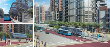
Rendering of the future Highway 7 rapidway

We’ve all seen examples of where a transportation system has caused a town to grow. Historically, many Ontario towns grew because they became a stop along a railway line. This was true for Markham in the late 1800s, when the Toronto and Nipissing Railway Company began stopping at stations in Markham and Unionville. Another cause for Markham’s growth was the post-Second World War baby boom and migration to the suburbs, and the building of Highway 404 in the mid-1970s. With the influx of high-tech industries, among other changes, Markham has seen an astonishing 25% population increase between 2001 and 2006, ranking Markham as one of the fastest growing municipalities in Canada.

Transportation plays a key role in growth and development, and Markham needs a system to help move the current and future population from place to place. VivaNext is building a rapid transit system along Highway 7 to give people a better transit infrastructure that will accommodate the current population and allow for future growth. As well as move people efficiently, rapidways encourage the development of transit-oriented and pedestrian friendly places to live, work and play. As you can see in the photo above, Markham’s rapidways will widen Highway 7 by two lanes and include two centre lanes dedicated to Viva vehicles and flanked by attractive architectural features and landscaped boulevards.

We’ve already started preparing for construction along Highway 7 in Markham by relocating hydro poles and other utilities to allow for road widening. If you’re interested in receiving construction bulletins and invitations to public meetings, be sure to sign up for updates.

When the snow melts you’ll see road construction begin along Highway 7, and we hope you’ll see past the short-term inconveniences and construction to the more welcoming, improved Highway 7 in Markham.